UPDATE: Wildfire near Hermiston prompts mobilizing 4 task forces
Published 4:06 pm Wednesday, July 2, 2025
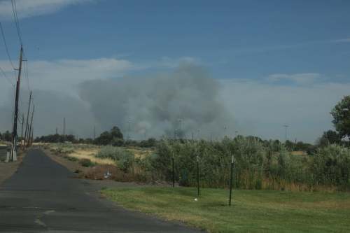
- A large fire July 2, 2025, in the Hat Rock area near Hermiston has closed Highway 37 from the junction with Highway 730 at milepost 0 to milepost 4. (Umatilla County Fire District No. 1/Contributed Photo)
HERMISTON — The fast-moving, wind-driven fire near Hermiston has prompted the Oregon State Fire Marshal to mobilize four task forces and an incident management team.
The Cold Springs Fire was reported Wednesday afternoon, July 2, and raced to more than 1,000 acres as of late afternoon, according to Umatilla County Fire District No. 1. The Umatilla County Sheriff’s Office has issued levels 1, 2, and 3 evacuation notices for those living near the fire.
The Oregon State Fire Marshal initially sent two structural task forces from Clackamas and Washington counties and air support through agreements with the Oregon Department of Forestry. To provide additional help, the agency is mobilizing its Green Incident Management Team and two more task forces.
The OSFM Green Incident Management Team will take command of the fire July 3 at 9 a.m.
“The latest wildfire forecast for July and August is extremely concerning,” State Fire Marshal Mariana Ruiz-Temple said in a press release. “Over the last 48 hours, we saw thousands of lightning strikes across the state, and red flag warnings issued for critical fire danger. I’m calling on everyone to pay attention to the conditions and take the necessary steps to prevent sparking a human-caused fire.”
The fire has led to the closures of Highway 37 from East Walls Road to Highway 730 and the Highway 730 exit to Diagonal Road, according to =
The Oregon Department of Transportation at about 8:30 p.m. reported Highway 37 was open near Umatilla from the junction with Highway 730 at milepost 0 to milepost 4 following an earlier closure due to the wildfire.
“While the highway is now open, a fire remains in the area,” ODOT advised. “Roads near wildfires may open or close with little notice, continue to use Tripcheck.com for updates.”
This is the third time the Emergency Conflagration Act has been invoked in 2025, and the third immediate response for the Oregon State Fire Marshal.
EVACUATION INFORMATION
LEVEL 3 (GO NOW!) from Tabor Road at East Walls Road and everything east to Highway 37 and everything south of Walls Road and Tabor Road to East Punkin Center Road along the railroad Tracks. (Hermiston area)
LEVEL 2 (GET SET) from Salmon Point all the way west to Hatrock.
LEVEL 1 (BE READY) from north of Hartle Road from Highway 37.
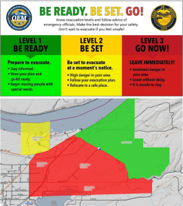
Umatilla County Sheriff’s Office/Contributed Graphics
Umatilla County Sheriff’s Office reported the Red Cross set up a shelter at the Eastern Oregon Trade and Event Center, 1705 E. Airport Road, Hermiston.
For fire updates until the Green Incident Management Team takes command, follow the Umatilla County Fire District 1. For evacuation information, please follow the Umatilla County Sheriff’s Office.
More to come.


-
eEdition

-

-