Imnaha fire explodes in size
Published 2:00 pm Thursday, September 1, 2022

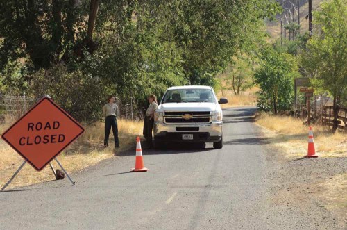
- The road to Hat Point Summit was closed Thursday, Sept. 1, 2022, at Imnaha because of trees felled by the Double Creek Fire. Emilie Wood, left, and Megan Ross of the Wallowa-Whitman National Forest were there to see that it stayed closed.
IMNAHA — The Double Creek Fire near Imnaha exploded overnight from about 50 acres to 1,500 acres on Thursday, Sept. 1, and mandatory evacuation orders were issued for some areas, according to the U.S. Forest Service.
Wallowa County Sheriff Joel Fish said in a press release at 5:30 p.m. Sept. 1 that the Hat Point Road above Imnaha was closed because of trees down across the road the fire brought down.
Trending
“There are fire crews trying to cut their way out,” he said.
No one was injured and no structures are threatened at present, he said.
Brian Anderson, district ranger for the Wallowa Mountains Office of the Wallowa-Whitman National Forest, said the 50-acre size of the fire was an “early assessment during the day” Wednesday, Aug. 31 and there was considerable fire activity overnight.
He said Aug. 31 “was a day conducive to burning with the heavy timber and winds.”
Fish’s mandatory evacuation orders had included all of Freezeout Road Aug. 31. By the evening of Sept. 1, that road was moved to Level 2 — the “Get Set to Leave” level. Level 2 also includes the Rippleton Creek drainage south to the Imnaha Grange.
The Level 1 areas — “Be Ready to Leave” stage — include the town of Imnaha south to the Rippleton Creek drainage, the Imnaha Grange south to the Pallete Ranch and the Imnaha River Woods.
Trending
Anderson and Fish said there are multiple bulldozers, fire trucks and aircraft battling the blaze. From the town of Imnaha, smoke is easily visible up the Imnaha River canyon, but the town itself does not appear threatened.
“The main focus is keeping folks safe,” Anderson said.
Wallowa County Commissioner Todd Nash said he and his fellow commissioners are keeping informed of the progress to fight the fire. He said it appears the blaze is being contained.
“These fires in the wilderness making quite a lot of smoke,” he said, “but so far they’re staying within bounds Forest Service hoped they would.”
He noted that fires are not unusual for the region.
“They call them the Blue Mountains because when the wagon trains came through, people looked over their shoulders and the country always looked blue because it was always on fire,” he said.
Part of the problem with fires in recent years, Nash said, is forest management.
“That’s in an allotment that should’ve been grazed,” the rancher said. “It’s unfortunate that there’s all that grass that should’ve been grazed that’s helping to carry that fire right now.”
But, he said, fire is part of the natural process in the wilderness.
“The positive thing about the fires is that they consume some of the fuel,” he said.
Nash said he was aware of bits of ash that fell on Enterprise Aug. 31 as a large cloud of smoke came up to the southeast from the Sturgill and Nebo fires.
“There were big chunks of black material with the ash,” he said.
Although the cloud no longer extended above the mountains as visible from Enterprise early Sept. 1, he doesn’t expect the fires are out. In fact, both have grown, according to https://inciweb.nwcg.gov.
The Sturgill Fire was at 4,815 acres midday Sept. 1 and the Nebo Fire was at 3,086 acres, up considerably from the previous day.
“It won’t be out until the snow flies probably,” Nash said.


