Double Creek fire breaks 100,000 acres
Published 10:30 am Thursday, September 8, 2022

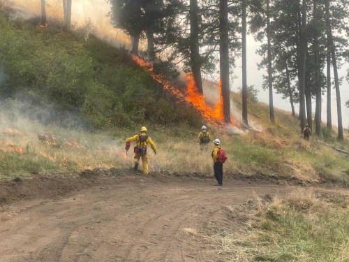
- Firefighters ignite areas near the Double Creek fire in Wallowa County on Sunday, Sept. 4, 2022. Crews use these back burns to reduce the amount of fuel near control lines. A similar back burn on Wednesday, Sept. 7, was undertaken to help protect the town of Imnaha.
IMNAHA — Brooke Van Sickle felt pretty confident as the Double Creek fire was scorching tens of thousands of acres over the past week not far from her home in Imnaha, but she still was glad to see much of the grass and brush on nearby slopes burned on Wednesday, Sept. 7.
She welcomed those flames because crews ignited on purpose to fight the the Double Creek fire in eastern Wallowa County, the biggest blaze this year in Oregon, estimated at 137,179 acres on Friday morning, Sept. 9.
Trending
Van Sickle said that the planned fire — known as a back burn, and intended to consume fuel between the main blaze and control lines — has left Imnaha, home to 29 people, well-protected from the fire sparked by lightning on Aug. 30.
“We feel safe here in town,” she said. “We have clear blue skies today. People are going about their daily business.”
Although the town has been on a Level 3 evacuation — leave now — for the past several days, Van Sickle said most Imnaha residents have remained.
Van Sickle and her boyfriend, Cody Mawhinney, have owned the Imnaha store, tavern and restaurant since April 2019. The business, in a building constructed in 1904, remains open.
Van Sickle said the situation is more dangerous for residents who live farther up the Imnaha River, in the Freezeout area where there’s more timber and homes built among the trees.
She said one couple who lives in that area evacuated and is staying in an RV on the property she and Mawhinney own in Imnaha.
Trending
Fire crews from the Oregon State Fire Marshal’s Office have been tasked with protecting structures in the Freezeout area and other places along the Imnaha River south of the town.
Mawhinney is from Baker City, where his parents, Robin and Chuck Mawhinney, live.
Robin Mawhinney said she visited her son on Sept. 7. It was her first trip to Imnaha since the Double Creek fire started.
Robin said she hasn’t been worried about her son and Van Sickle, in part because they have a lot of green grass around their property.
Robin said she saw the results of the back burn on Sept. 7 and agreed with Van Sickle that the intentional fire did much to protect Imnaha.
“The town is pretty much protected,” Robin said.
She said she has been talking with her son by landline phone daily since the fire started.
“He wasn’t that worried,” she said. “They’re taking it all in stride.”
The Double Creek fire grew substantially on Sept. 7, fueled by wind gusts up to 50 mph from a passing cold front. The fire expanded by about 30,000 acres.
The back burn near Imnaha was done before the stronger winds arrived, according to an update from the fire’s incident command team.
The back burn near Imnaha was done before the stronger winds arrived, according to an update from the fire’s incident command team.
The fire was less active on Thursday in the cooler temperatures and higher humidities that followed the cold front.
Containment increased to 15% due to work on a 10-mile corridor along the Imnaha River between the town of Imnaha and Freezeout Road.
The fire did spread east to the Snake River near Pittsburg Landing on Sept. 8, and a group of firefighters has been assigned to protect structures along the river if needed.
A total of 652 people were assigned to the blaze as of Friday morning.
Eagle Cap Wilderness fires
A trio of lightning-sparked blazes continues to burn in the wilderness. These are “managed” fires, meaning crews are monitoring the blazes and taking steps, such as having helicopters drop water, to try to limit the fires’ spread toward the wilderness boundary and private property.
The largest of the blazes, the Sturgill fire on the east side of the Minam River, had minimal activity on Thursday and was estimated at 18,715 acres by the morning of Sept. 9.
The Nebo fire, about 20 miles to the southeast at the east end of the wilderness, was estimated at 11,668 acres and also was relatively quiet Sept. 8.
The Goat Mountain 2 fire, estimated at 466 acres, is near the Sturgill fire. The fire was active Sept. 8 on top of the Lostine Divide, and helicopters were assigned to drop water on the fire as needed Sept. 9.
Crockets Knob fire
The other large blaze in the region, the Crockets Knob fire on the Malheur National Forest about 19 miles north of Prairie City.
The fire is 50% contained and has burned an estimated 4,331 acres.
SALEM — To boost capacity ahead of forecasted east winds and heightened wildfire conditions, the Oregon Office of State Fire Marshal has ordered three Washington task forces from Snohomish, King, Pierce, Kitsap, Chelan and Clark counties through the Emergency Management Assistance Compact.
The State Fire Marshal said in a press release on Thursday, Sept. 8, that one Washington task force will be assigned to the Double Creek Fire in Wallowa County. while two task forces will be pre-positioned in Wasco and Lane counties. The added resources will give the Oregon Fire Mutual Aid System added capacity to respond quickly should a fire happen and support local fire agencies.
“We want to thank the Oregon fire service and our partners from Washington for their dedication to protecting Oregon communities,” Oregon State Fire Marshal Mariana Ruiz-Temple said in a press release. “This extra capacity will allow our office to be nimble and help local fire agencies during this critical point in the fire season. We ask those who live in Oregon and those visiting to be aware of the dry conditions and take the necessary steps to prevent sparking a wildfire.”
Currently, the OSFM has an incident management team and 11 task forces assigned to the Double Creek and Sturgill fires in Wallowa County. Two strike teams were mobilized on Wednesday, Sept. 7. to support the Van Meter fire in Klamath County.


