On the trail | Just passing by
Published 6:00 am Saturday, September 14, 2019
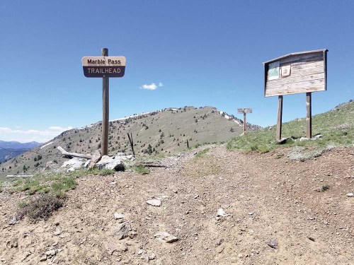
- Marble Creek Pass in the Elkhorn Mountains west of Baker City is also the southern terminus of the Elkhorn Crest National Recreation Trail.
Some of the more memorable climbs I’ve made in the mountains brought me to low ground rather than high.
Well, sort of.
The summits in these cases are low only by comparison to their surrounding topography.
By any other measure, though, they are quite elevated.
It is no coincidence that mountain passes, though by definition they occupy the place where a ridge, or in some cases an entire range, dips, are often described as “high passes.”
Humans have a particular fascination with superlatives, of course. This explains in part why mountain peaks, and especially those that dominate the terrain for dozens of miles around, hold us in such awe.
Passes, by contrast, which typically afford travelers a way to avoid rather than surmount a summit, are less likely to inspire poetic odes to the grandeur of nature.
It’s why the Theodule Pass in the Swiss Alps is relatively obscure — so much so that the internet seems unable to agree on whether to include the final “e” — but the peak it skirts — the Matterhorn — is perhaps the most famous mountain in the world.
But even though passes tend to languish in the shadows of nearby summits, both literally and figuratively, some of these breaches in mountainous ramparts have yielded a cultural history at least as rich as those of neighboring peaks.
This is logical, given that passes serve the basic purpose of allowing us to get where we want to go as efficiently as possible.
Climbing inaccessible peaks, by contrast, has always struck some of the more sober-minded among us as folly — and worse still the sort of folly than can leave a climber with toes blackened by frostbite or a skull dashed in by a tumbling chunk of granite or limestone.
To critics there is a strong and bitter flavor of selfishness to the enterprise, this risking of precious life for a dubious achievement that serves no greater good.
Discovering and then utilizing a mountain pass, by contrast, is the sort of endeavor that has a wider societal appeal — and, often, benefit.
Blazing trails and railroads and highways through wild country can also be dangerous, of course, what with the nature of mountain weather and the occasional avalanche or landslide or antagonistic grizzly.
But for some people the potential sacrifice can at least be justified if, for instance, the effort opens a new trade route, traditionally a common reason to devise a passage through the mountains.
I’ve long been intrigued by the history of passes, and in particular their progression from footpath to wagon train to, in many cases, modern highway.
When I started hiking regularly as a teenager my interest in passes expanded to include ones that, rather than becoming thoroughfares where 18-wheelers groan their way up 6% grades, remain rudimentary, with only a trail marking the passage.
When I was growing up in Stayton, on the eastern edge of the Willamette Valley, I was especially enamored of two passes through the Cascades — the Santiam and the McKenzie, each named for a nearby river and both crossed by a paved highway.
We drove across the Santiam Pass whenever we visited Central Oregon and even today, after living for a few decades on the other end of the state, the elevation of its summit — 4,817 feet — comes to mind as easily as my phone number.
We never called it anything except just “the pass,” it being unnecessary to specify which one we meant.
(I like these examples of a community having such a familiar relationship with its topography. Another prominent case is Seattle, where residents, when they refer to “the mountain,” needn’t bother saying “Mount Rainier.”)
McKenzie Pass, the next major socket in the toothy chain of Cascade volcanoes south of the Santiam, has always impressed me with its expanses of barren lava, so different from the forested Santiam Pass.
(Although the B&B Complex fire, which swept through the Santiam in 2003, significantly altered its appearance.)
It always pleased me too to know that the McKenzie, owing to its greater elevation (5,325 feet, a number that also never seems to grow dim in my memory even as so many other inconsequential details fade) and its steeper grades and surfeit of sharp corners, usually is blocked by snow for more than half the year because plowing it clear is too expensive to justify.
(The proximity of the Santiam Pass also makes the McKenzie, which actually has had a highway for longer, somewhat superfluous, traffic-wise.)
As a child I also learned, mainly through books, about a few other noteworthy passes.
These include Wyoming’s South Pass, the opening through the Rocky Mountains so vital to the success of the Oregon Trail, and Donner Pass in Northern California’s Sierra Nevada, where a group of emigrants came to such a bad, and grisly, end during the winter of 1846-47.
But for all my interest in passes that have been civilized to a great degree, my favorite encounters with these topographic features have happened on foot.
Much of this is due to the nature of walking compared with driving.
It is quite a different experience to ascend a pass at a placid pace than at 55 mph, to smell the fresh scent of sun-warmed fir rather than upholstery, to feel the cool breath of an alpine breeze when you come round a switchback and not the artificial frigidity that issues from a vent.
I greatly admire the engineers who conceive a way to lay a swath of pavement across inhospitable terrain. Yet it’s that very skill that transforms the crossing of a pass from an intimate experience, one in which the anticipation builds gradually but powerfully with each of thousands of steps, to an anodyne blur lasting no longer than a song on the stereo.
I am fortunate to live so near the Wallowas, a mountain range with a passel of prominent passes.
This has much to do with geography. The Wallowas comprise about 10 major canyons and considerably more ridges, and any practical trail network by necessity must include passes that bridge these divides.
Over the past 15 years or so I’ve managed to cross many of the Wallowas’ named passes, and a few that don’t have a name.
The most dramatic to my eyes (and, frankly, stomach) is Polaris Pass. It’s the highest pass in the range with a constructed trail, at 8,800 feet.
But its distinguishing characteristic, at least when you approach it from its gentler eastern side, as I did on my two visits, in 2012 and 2017, is how suddenly the panoramic view explodes at the top.
I think the adjective “breathtaking” an especially trite cliché, but in common with that breed it sometimes captures a feeling as well as any other option.
Reaching Polaris Pass is just such a case.
Almost every pass boasts a fine view, of course — such is the nature of high ground (even “lower” high ground).
But Polaris Pass is different — the way the west side plunges so precipitously, the way the grand sweep of the Wallowas’ granitic midsection is exposed, unobscured by any intervening terrain — that I have yet to find anything like its rival.
But each pass offers rewards that more than justify the toil required to reach it.
I relish all of them — Hawkins, Horton, Glacier, Frazier, Wonker, Ivan Carper, Burger, Sand, and the curiously unnamed passes above Arrow and Cached lakes west of Eagle Creek.
The Elkhorns, where I’ve spent considerably more time than in the Wallowas, are comparatively deficient in notable passes.
The Elkhorns are a much smaller range, for one thing. And although there are several substantial canyons in the Elkhorns, few of the intervening ridges are crossed by trails.
Also, two of the major passes in the range — Marble Creek and Elkhorn Summit — are reached by roads, paved in the latter case.
Then too there is a difference in nomenclature.
The longest trail in the Elkhorns — the Elkhorn Crest Trail — as its name implies generally follows the crest of the range’s main spine, and although the path crosses this divide several times, most of these spots are called saddles rather than passes.
Naming convention aside, I am always gratified to arrive at Cracker Saddle, or Cunningham or Dutch Flat.
There are also a couple of proper passes along the Crest Trail — Angell, the high point south of Anthony Lakes, and the piquantly named Nip and Tuck above Lost Lake.
The lack of consistency among names in the Elkhorns isn’t unique.
There is a regional aspect to branding passes just as there is with, say, the various versions of describing sweetened, carbonated water, which goes by, among other monikers, soda, pop, coke and tonic.
What I call a pass a Vermonter or New Hampshire resident likely would deem a notch (as in Franconia Notch in the latter state), and a Virginian might describe as a gap (as in the Cumberland Gap).
I like that these differences exist. They highlight the richness of our language.
As an aside, I’ve long wondered about what seems to be a local anomaly in describing another landform — the valleys, typically roughly circular and often with a meadow or seasonal meltwater pond, that form near the base of a ridge.
On the west side of the Elkhorns, between Cracker and Dutch Flat saddles, three of these features, all in a line about 2 miles long, are called “coves” — Mount Ruth, Bill Brown and Cunningham. A fourth example, a few miles to the southwest, is Cable Cove at the head of Silver Creek.
The city of Cove in Union County, originally called Forest Cove, has a similar topographic origin.
What seems to me passing strange is that cove, in this context, is most commonly used in the southern Appalachians. Its synonyms include “hollow” or, to capture regional dialects, “holler.”
I don’t know how the quartet of high valleys in the Elkhorns came to be known as coves, while almost every other similar place in the region is not. Unfortunately my most reliable arbiter on such questions — McArthur’s irreplaceable “Oregon Geographic Names” — is silent on the matter.
I suspect, though, that there is a Southern connection.
The first gold rush in Northeastern Oregon, spurred by Henry Griffin’s discovery of the precious metal in a gulch near present-day Baker City on Oct. 23, 1861, happened to coincide with the Civil War.
The subsequent onslaught of fortune-seekers into the Blue Mountains included a goodly number of prospectors who were either from the Confederacy or at least sympathetic to its aims.
This sentiment is reflected in several place names across the region including, to name a couple of the more obvious, Dixie Butte and Jeff Davis Creek.
The other side of that conflict is even more amply represented on the map. Both Dixie Butte and Jeff Davis Creek are in Grant County, whose neighbors include Union County and Baker County. The latter was named for U.S. Sen. Edward Dickinson Baker, a close friend of Abraham Lincoln and a colonel in the Union Army who was killed at the Battle of Ball’s Bluff in Virginia. Baker died on Oct. 21, 1861.
Two days later, and most of a continent away, Griffin glimpsed those pale yellow flakes, making a very different sort of history.