Drones aid land research, but worries remain
Published 9:00 am Thursday, February 14, 2013
- Drones aid land research, but worries remain
Unmanned aircraft are cheaper, safer than choppers, planes
Capital Press
A technology known for its deadly strikes against suspected terrorists in the Middle East could one day be unleashed against invasive species across the American West.
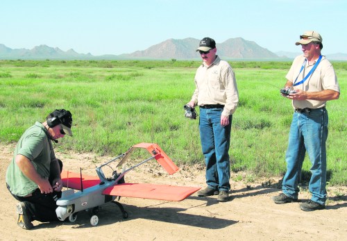
Unmanned aerial vehicles — called UAVs or drones — are commonly associated with the missile-toting remote-controlled aircraft that patrol the skies over faraway lands like Pakistan and Yemen, but researchers in the U.S. are pressing their unarmed cousins into service for a variety of civilian uses.
Across the vast public lands of the West, the U.S. Bureau of Land Management and the U.S. Forest Service face competing interests in monitoring remote habitats. Land managers are being pressed to step up monitoring of rangeland health even as the manpower and money for surveillance dwindles, said Al Rango, a research hydrologist with the USDA.
“You keep telling them that, and they will eventually come and use remote sensing data,” he said.
Rango has studied the use of unmanned aircraft at the Jornada Experimental Range in Las Cruces, N.M., for more than five years and sees them as an elegant solution to the dilemma faced by public land managers.
Operating UAVs is cheaper and safer than manned aircraft, he said.
While the cost of expanding surveillance with a UAV becomes marginal after a certain point, the expense of boots-on-the-ground monitoring rises in proportion to the amount of land surveyed, Rango said.
“It keeps building,” he said.
As a hydrologist, Rango initially used UAVs to track snow runoff and stream flows but then began studying vegetation to evaluate rangeland health.
Photos taken by UAVs can easily let scientists distinguish between bare ground and vegetation, and special “multispectral” cameras help them identify specific types of plants. Different species of plants reflect and absorb different wavelengths of light.
This information can be used to tell a desirable native grass from an invasive plant like cheatgrass when aerial photos are compared to species data previously collected on the ground.
“It’s more reliable to use that approach to tell one type of vegetation from another,” compared to regular aerial photos, Rango said.
The potential uses of UAVs are many.
Land managers and ranchers could use them to figure out how much of the ground cover in an area is edible for livestock, said Mark Seyfried, a USDA soil scientist at the Northwest Watershed Research Center in Boise, Idaho, who has worked with Rango.
Accurate aerial information could also serve as a weapon against invasive species by letting managers gauge the spread of weeds over time, Seyfried said.
“One of the most important things is knowing where they are and what the sources are,” he said.
Seyfried said the technology could eventually be used to study the management of cattle on public lands, but flight regulations limit further testing.
Under current Federal Aviation Administration regulations, the operator must always keep a UAV within sight — undermining the technology’s use across vast landscapes of difficult terrain, he said.
“As long as you’re tethered to your base, it’s not that useful for what we want to do here,” Seyfried said. “That’s a huge limitation as far as I’m concerned.”
For ranchers, the prospect of unmanned aircraft hovering over grazing cattle is a double-edged sword.
On one hand, environmentalist lawsuits have cited federal managers’ insufficient oversight of rangeland health as a reason livestock should be kept off public lands.
“They just haven’t been able to get monitoring done that needs to be done,” said Brice Lee, a rancher near Hesperus, Colo., and president of the Public Lands Council, which supports grazing. “To keep up to date has been hard for them.”
Unmanned aircraft could be a good way of documenting the health of allotments, he said. “We need to know how the range is reacting.”
On the other hand, some ranchers say they doubt an unmanned aircraft flying high above rangeland can accurately record key details that determine environmental health.
One of the key ways to check the effects of grazing is stubble height — the length of the grass left standing — which wouldn’t appear easy to measure from overhead, said Bob Skinner, chairman of the public lands committee of the Oregon Cattlemen’s Association.
“My concern is I don’t know if they’ll get the monitoring done correctly,” he said.
Another metric that doesn’t seem measurable from the air is bank alteration, or the percentage of stream bank affected by hoof prints, said Loren Stout, a rancher near Dayville, Ore., who is involved in litigation over grazing.
“I don’t see the benefit to it, to tell you the truth,” Stout said of aerial surveillance.
When asked about these perceived shortcomings, Rango acknowledged that stubble height cannot currently be measured with UAVs but advances in laser systems that measure the distance of objects could allow them to track grass height in the future.
As for bank alteration, Rango said the aircraft can already fly low enough to be used to monitor erosion and alteration from livestock.
Doug Johnson, a rangeland ecology professor at Oregon State University, said UAVs will likely be useful for watching trends like the density of sagebrush. As for grazing management, it will probably serve as a supplement to current methods, Johnson said.
“It’s not going to replace people out on the ground looking at things,” he said. “It’s like any tool. It’s going to have limitations.”