Over the Blues: Hill offers panoramic views of Wallowa Mountains
Published 7:00 am Saturday, March 22, 2025


If you go now you might not witness day-glow green baby grasshoppers taking their first hops, as I did on a climb of Tick Hill last June.
Then, winter was a distant memory.

Peterson
Now the snowy season is just giving way to spring, which is an excellent time to explore this landmark just north of the town of Wallowa.
Trending
To reach Tick Hill, take Whiskey Creek Road on the northeast edge of town. Drive about a half mile to the Nez Perce Wallowa Homeland site, enter the grounds and continue a quarter mile. At the northeast corner of the loop road you will find parking and a sign marking the start of the trail.
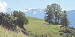
The 3-mile loop trail starts on an old road, which follows a fenceline east. On the south side of the fence, angus cows get frisky. On the north side, marmots scramble into rocky hiding places at the base of basalt cliffs. Swallows swirl in updrafts around the spires.
Soon, as I turn north, the skinny trail starts. Switchbacks climb the hill. From here it’s a typical Blue Mountains barely-wider-than-a-gymnast’s-balance-beam-but-walkable trail.
Purple lupine and Indian paintbrush dot the hillside, as do arrowleaf balsamroot, whose gold rush bloom reaches a peak in May. Flowers are thronged by moths using them as helipads.
Teasel also love the southern exposure hillside as they dance in the breeze.
The best time to hike Tick Hill is late fall and spring. Wallowa average highs and lows are March, 52/28; April, 60/32; May, 69/38; June, 77/44.
Trending
Summer can be blistering hot.
Whenever they visit, hikers are encouraged to bring ample water, sunscreen and a hat for shade.
Birdsong accompanies my scramble up a windswept gulch. A meadowlark, Oregon’s state bird, performs a solo. Warm breeze rushes through the tall grass.
The trail gives way briefly to a service road, then resumes its skinny meanderings as I approach the summit. Blustery winds try to steal my hiking hat. Clouds sail by, heading toward Idaho.
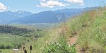
Airy vistas unfold of rugged snowcapped peaks in the Eagle Cap Wilderness and, far to the east, the Seven Devils rising out of Hells Canyon. The sprawling Wallowa Valley is a patchwork of lush green fields.
A star perches cliffside for the town Christmas celebration. Communication towers sprout.
Beyond, the skinny trail passes several interpretive markers — bronze plaques on large stones — a tribute to this important site for the New Perce tribe. One message reads, “Always honor those who have gone before you.” Another reads, “We are born of our mother. Our physical remains return to her when we die.”
An ancestral cemetery is nearby. Looking over the valley, I imagine life before the arrival of white people.
I proceed down a vale. After crossing a swale, with expansive views to the west, I descend switchbacks to the valley floor.
Near the bottom, a pair of redtail hawks swoop around a tall pine tree, guarding a nest. I press on. Cliffside flower gardens welcome me to the bottom of the hill.
Finally I reach a one-lane road that follows the foaming chocolate torrent of the snowmelt-infused Wallowa River upstream back toward the trailhead and completion of the loop.
In the swamp, redwinged blackbirds sing.
In river back channels, Canada geese parents give their young swimming lessons.
As always, leave only footprints and take only pictures. Whether in town or on the trail, try to leave your surroundings better than you found them.
Jeff Petersen is an outdoors enthusiast who enjoys hiking, bicycling, jogging and other low-budget entertainment. He retired after a 40-plus year career, mainly in newspapers, and lives in Milton-Freewater. Reach him at jeffp557@gmail.com.
Marketplace


-
eEdition

-

-
