Wildfires continue to make homeowner insurance expensive, hard to get
Published 1:00 pm Thursday, September 19, 2024
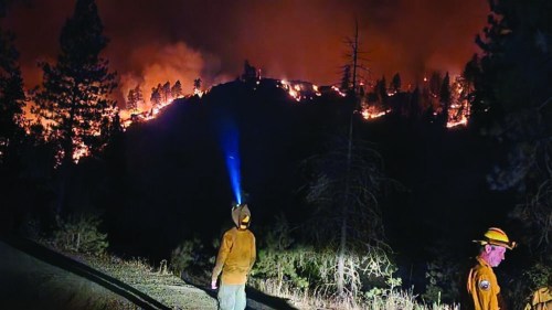
- The Town Gulch Fire made a massive run on Aug. 6, 2024, spreading east to the West Wall above Pine Valley.
BAKER CITY — Wildfires will continue to threaten not only homes in Oregon but also the ability of homeowners to insure their property.
That’s one of the messages members of Oregon’s Wildfire Programs Advisory Council heard during a webinar Sept. 19.
Mark Bennett, a former Baker County commissioner who owns a ranch near Unity, is a member of the council, as is attorney Susan Jane Brown, of John Day, representing environmental interests.
The council heard from Alexandra Syphard of the Conservation Biology Institute and Kenton Brine, president of the Northwest Insurance Council. Syphard talked about the significant increase in large wildfires, and the number of houses destroyed in those blazes, during the past several years.
Brine discussed how those trends, which have resulted in hundreds of billions of dollars in insurance claims, have made homeowner insurance with fire protection both harder to get and more expensive.
One of Oregon’s worst wildfire seasons is on the wane. Blazes have burned more than 1.7 million acres statewide this year, with the majority of those areas in Eastern Oregon.
The number of homes burned, however, has been much lower than in the Labor Day fires of 2020, which destroyed several hundred homes west of the Cascades.
Fire risk models and maps
Insurance companies use computer models, and the maps they generate, to determine the wildfire risk for specific properties. That risk level influences whether a company will offer policies to residents, and how much the company will charge.
One of the challenges, though, is about 100 companies sell insurance in Oregon, and they don’t all use the same model or map, Brine said.
Syphard, who said she has worked on such maps for multiple companies, said each used a different model.
“Not all maps are right,” she said during the webinar.
The issue of maps, and their accuracy, has been a major one in Oregon the past two years.
The Oregon Department of Forestry in 2022 unveiled a map showing wildfire risk across the state. Creating the map was part of a bill the Oregon Legislature approved in 2021, in the wake of the Labor Day 2020 blazes that destroyed hundreds of homes in Western Oregon.
The map prompted rapid and widespread criticism. Many critics said the map didn’t accurately portray the relative risk of wildfire.
In addition to complaints about the map itself, many property owners said their homeowner’s insurance policy had either been canceled, or not renewed, around the time the state unveiled the map. They blamed the loss of insurance on the state’s new map.
Although Oregon’s insurance commissioner said the state investigated those claims and found no proof they were true, Brine said during the webinar that flaws in maps and other data, such as satellite photos of properties, can influence insurance companies.
He cited as an example a property owner who was denied insurance coverage because, according to the company, a satellite photo seemed to show a dense forest on the property.
But Brine said that due to the angle of the light when the photo was taken, the image was in effect an illusion — what appeared to be trees were not.
The homeowner showed the company photos taken on the ground, proving there were no trees at all.
Brine said the company admitted its mistake and offered to sell the resident a policy.
The resident told the firm “to pound sand” and sought a policy from a different company, Brine said.
The Oregon Department of Forestry, in response to the public outcry about the 2022 map, withdrew it. The agency released a new map in July of this year.
Syphard said the issue is complicated.
A map that shows, for instance, areas where a fire is likely to grow rapidly does not necessarily mean homes in that area are at great peril, she said, because in that same area the risk of any fire being started might be relatively low.
Creating defensible spaces around homes
Syphard and Brine agreed residents can take certain steps to help protect their homes. Common techniques for creating a “defensible space” include clearing an area of easily burnable debris, such as storing firewood away from the house, and keeping grass and vegetation well-watered.
Some insurance companies will offer discounts to properties that are in such areas, he said, although other programs, which require annual inspections to ensure the defensible space work is maintained, are more likely to qualify for discounts.
But Brine and Syphard also said some tactics widely believed to be vital aren’t necessarily so. For instance, installing a metal roof, although it can help protect a home, might be no more valuable than installing mesh screens on air vents to prevent embers from entering a home, Brine said.
Syphard said most homes that burn are ignited not by direct flames but by flying embers. The screens are considerably less expensive than a metal roof, however.
She added research has also revealed flaws in how wide defensible spaces need to be. Some insurance companies won’t insure properties that lack a defensible space of 200 feet or wider.
“The science doesn’t support that,” she said.
She recommended a width of 100 feet, which also can help protect firefighters.
The speakers also said it’s valuable for residents to coordinate with their neighbors, as even a single neglected property can pose a major risk to surrounding parcels if a fire starts.
Brine said formal agreements, such as the Firewise Community program through the National Fire Protection Association, can help protect homes.
Brine said the trends of the past several years, with fires destroying more homes — and with inflation greatly increasing the cost to replace those homes — will continue to make it challenging for residents who live in fire-prone areas.
“You have to work harder than ever before to find coverage in some areas,” he said.
California fires a ‘window into the future’
Syphard showed council members slides depicting the prevalence of large fires in California that not only burn large swathes of land but destroy hundreds and in some cases thousands of homes.
Of the 20 largest fires in California’s history, 17 have happened since 2000, Syphard said.
Although Oregon has yet to have wildfire disasters on a similar scale except for the Labor Day 2020 blazes, Syphard said California’s experience could be a “window into the future.”
Syphard said she believes in forested areas of Oregon, the best way to help protect homes, in addition to the defensible space work residents can do, is to have land management agencies thin crowded forests and follow with prescribed burning to reduce the amount of fuel.
Jayson Jacoby is the editor of the Baker City Herald. Contact him at 541-518-2088 or jjacoby@bakercityherald.com.