Rail Ridge Fire prompts public closures near Dayville
Published 6:27 am Thursday, September 5, 2024
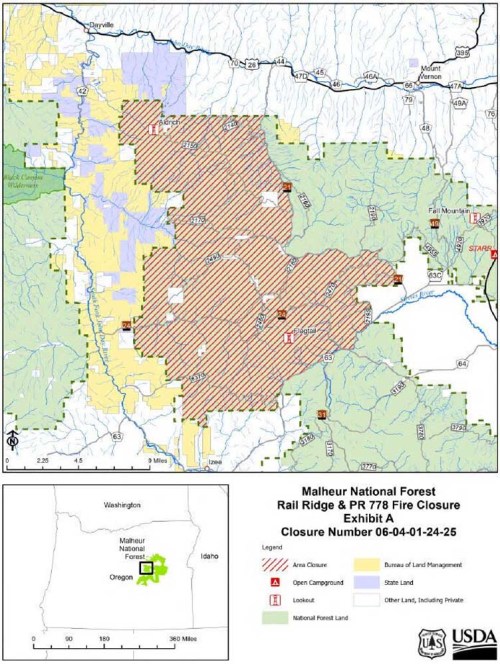
- Map shows area of Malheur National Forest closed to the public due to the Rail Ridge Fire south of Dayville.
DAYVILLE — The Rail Ridge Fire in Grant County has prompted the Oregon Department of Fish and Wildlife to close the Phillip W. Schneider Wildlife Area near Dayville to public access until further notice.
Lightning started multiple fires on Sept. 2 near the South Fork of the John Day River. The fires grew together and have burned more than 80,000 acres. The fire has burned large areas of the Murderers Creek flats and areas to the north. The fire continues to be a significant safety threat on all wildlife area lands.
In addition to the closure of the Phillip W. Schneider Wildlife Area, the Malheur National Forest has closed an area of the forest due to the fire.
The closure area:
• Starting at the national forest boundary on Fields Peak Road/Forest Service Road 21 on the border of Township13S, Range 28E, Section 35 and T14S, R28E, Sec.1 south along Forest Service Road 21 to T15, R29E, Sec. 18.
• Along Forest Service Road 21 east and south to the national forest boundary in T15S, R30E, Sec. 29.
• Following the national forest boundary south to Grant County Road 63 on the border of T16S, R29E, Sec. 12 and T16S, R30E, Sec. 7. Continues southwest along Grant County Road 63 to the border of T16S, R29E, Sec. 31 and T17S, R29E, Sec. 6.
• Following the national forest boundary west to T17S, R28E, Sec. 7, north to T13S, R27E, Sec. 33, east to Fields Peak Road/Forest Service Road 21 on the border of T13 S, R28E, Sec 35 and T14S, R28E, Sec. 1.


-
eEdition

-

-