Out and About: Sampling the history, and the huckleberries, around Olive Lake
Published 5:15 am Monday, August 26, 2024
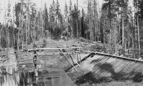
- This photo from 1926 shows the dam on Lake Creek, above Olive Lake, that created a reservoir that helped supply water to the Fremont Powerhouse. The dam was later dismantled and the former reservoir is now a meadow.
There happens on occasion a magical moment when the sun, after exuding only malevolence for many weeks, suddenly brings instead a pleasant and welcome warmth.
I relished just such a moment late on the morning of Aug. 18.
I was hiking near Olive Lake, in the Umatilla National Forest west of Granite, with my wife, Lisa, and our son, Max, who’s 13.
We had walked just a few hundred yards on the Saddle Camp Trail, which starts near the lake’s southeast corner, when we noticed that the south wind shoving around the lodgepole pines felt decidedly autumnal.
Goosebumps dotted my forearms.
It occurred to me that I should have brought a jacket.
But I didn’t berate myself for the oversight.
The notion that extra garments might be necessary has been farcical for most of this torrid summer.
July was the hottest month on record at the Baker City Airport.
(And it wasn’t close; the average high for the month was 2.6 degrees higher than any before at the airport, where records date to 1943.)
Triple-digit temperatures have never been so common in Northeastern Oregon.
The breeze, when it has deigned to blow, has brought no more relief than opening the door to a kiln would do.
But at that instant, as we climbed along the corridor between the pines that have proliferated since a fire scorched much of the area around the lake about two decades ago, I could sense, for the first time, that this record-setting summer at last was on the wane.
When we came to a brief opening in the forest, where the shadows gave way to full sun, Lisa voiced what I had been thinking — that the sunshine was a balm rather than an incipient blister.
The Saddle Camp Trail, and Olive Lake, are fine places to greet the changing of the seasons.
The signs of this inevitable shift, with nearly two weeks of August remaining, were subtle, to be sure.
Just half an hour or so after we paused briefly to let the rays erase the goosebumps, the sunshine had begun to assert itself as it typically does in August.
I felt beads of sweat on my neck and dampening my T-shirt beneath my backpack.
The deep woods exhaled the inimitable summer scent of warm bark and needles.
An occasional grasshopper skittered across the path, their distinctive clicking one of the familiar seasonal sounds.
But even as we started up the steep ascent to Saddle Camp, on the granitic crest of the Greenhorn Mountains, the heat never reached the oppressive level that has defined the summer of 2024.
Each patch of shade, each freshening of the breeze, was as soothing as a swig of chilled soda.
Saddle Camp Trail is something of a siren — in the Greek mythology sense.
The trail entices you with its gentle grades for about 2½ miles from its start at Olive Lake.
But when the path veers off its generally southwest bearing to head due west, it attacks the steep slope directly, with none of the switchbacks that distinguish so many trails in the Eagle Cap Wilderness.
The trail gains about 600 feet of elevation in the final three-quarters of a mile, a grade that your legs and lungs can’t help but notice.
Olive Lake, with its fine campground, boat ramp and dock, is the main attraction in this corner of the Umatilla National Forest.
The lake, at an elevation of 6,000 feet, is a reliable refuge from the worst heat waves, with its clear, chilly water. It’s an excellent lake for small boats, as well as kayaks and paddleboards, although afternoon winds can whip up significant whitecaps.
People with more tolerance than I have for cold water — I have precisely none — might enjoy a swim.
But besides the liquid lure of the lake, the Greenhorns also have an extensive network of hiking trails, many of which, as with parts of the Saddle Camp Trail, are within the North Fork John Day Wilderness.
The round trip distance from the lake to Saddle Camp and back is 6½ miles.
The trail is also part of a 12-mile loop, via the Blue Mountain and Lost Creek trails, that follows the crest of the Greenhorns for several miles.
Rich history
The Olive Lake area is historical as well as scenic.
Although the lake is natural, it was enhanced by the construction of a dam in the first decade of the 20th century. The dam increased the lake’s level by 35 feet, and expanded its size from 95 acres to 165 acres, according to a 1981 application the Forest Service filed to add the area to the National Register of Historic Places.
The focus of that application wasn’t Olive Lake but rather the structure that was the destination for its water — the Fremont Powerhouse.
The powerhouse, about 7 miles east of the lake, opened in 1908 and produced electricity for mines and other properties until 1967. Water from Olive Lake was conveyed to the Fremont Powerhouse in a pipeline made of redwood staves. With a considerable pressure — the lake is more than 1,000 feet higher than the powerhouse — the water spun turbines that generated electricity. Sections of the pipeline remain and are visible from Forest Road 10, the gravel road that passes Olive Lake and continues west for 25 miles or so to Highway 395 near Dale.
According to the application for National Register of Historic Places status — which was granted — in addition to damming Olive Lake, workers dug ditches to augment the lake, if needed, with water from the North Fork of Desolation Creek, west of the lake, and from Lost Creek just to the east.
Crews also constructed a second dam.
This one blocked Lake Creek, which starts near Saddle Camp and flows north into Olive Lake. This smaller dam created what was called, with a certain lack of imagination, Upper Reservoir.
Although the dam was long ago dismantled, remnants are still visible near where the Saddle Camp Trail crosses Lake Creek, about half a mile from Olive Lake.
As for the reservoir, which once sprawled across several acres, only a comparative puddle remains. What’s left is a classic mountain meadow, its hip-high grass turning tawny in the late summer.
(Beware, though, that the meadow, even after so many weeks of heat, is still swampy. Max, and in particular his shoes, discovered this when he stepped into the meadow.)
The trail is nearly flat as it follows the west side of the meadow. And for the next mile or so the path climbs only gradually as it continues south up the Lake Creek valley.
The transition to a steep ascent is sudden.
After the trail heads away from the stream, where the coneflowers, lupine and other vegetation were lush and green in defiance of the desiccating summer, it climbs relentlessly.
The trail becomes indistinct as it levels out in the saddle between two granitic knobs. The gray-white sun-bleached skeletons of burned trees, their blackened bark long since having shed, lie scattered about. A couple of rock cairns mark the way, though, and even if you lose the path, if you keep walking west for 50 feet or so you’ll intersect the Blue Mountain Trail.
The Saddle Camp Trail was in good shape otherwise. A trail crew had been there recently, leaving drifts of sawdust where they cut through trees that had fallen across the trail. We appreciated their labors, which spared us from having to clamber over logs, a task that for me invariably leads to scratches and the occasional puncture wound to the leg.
We also appreciated the huckleberries.
The bushes were scattered, but many were heavy with fragrant, sweet fruit. The area near the Lake Creek crossing, just below the Upper Reservoir, was especially juicy, as it were.
If You Go
The Saddle Camp Trail starts at Olive Lake, along Forest Road 10 between Granite and Highway 395. If you’re coming from Baker City, La Grande or other points to the east, drive to Granite and then head west on paved county road 24 for 3.6 miles, then continue to the right and uphill on gravel Forest Road 10 at a sign for Fremont Powerhouse and Olive Lake. Continue about 8 miles to the Olive Lake Campground. Stay to the left on the campground road to its end in a turnaround. The Saddle Camp Trail starts at the left side of the turnaround and heads straight uphill into the forest.
If you’re coming from Pendleton or points west, drive Highway 395 to the junction with Forest Road 10, which is between mileposts 64 and 65, just south of the North Fork John Day River. Olive Lake is about 25 miles east of Highway 395.


