Out and About: Hankering for huckleberries
Published 5:15 am Tuesday, July 30, 2024

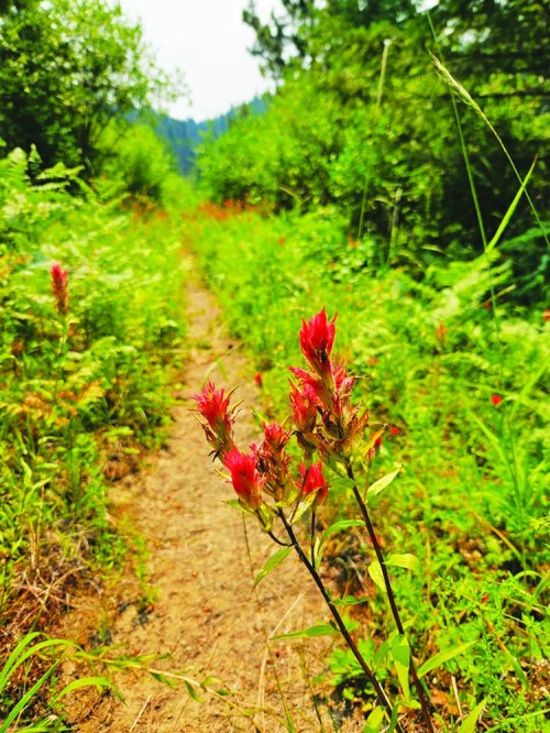
- Paintbrush blooms along the Lake Creek Trail in the North Fork Umatilla Wilderness east of Pendleton.
Mountain trails are abysmally lacking in vending machines.
But nature can occasionally conjure a decent imitation.
The treats are free, too, although you’ll probably come away with purple-stained fingers.
My wife, Lisa, and I went hiking in the northern Blue Mountains on the afternoon of July 21. It was the latest in a seemingly interminable string of torrid days, and as the day progressed the blue sky was smudged with the smoke from distant fires and it smelled like the time when s’mores are ready to be assembled or wieners roasted.
It was our first visit to the North Fork Umatilla Wilderness.
Part of Oregon’s wilderness class of 1984, when Congress designated 22 new wilderness areas in the state, the North Fork Umatilla covers 20,300 acres.
That’s tiny compared with the nearby Eagle Cap Wilderness, Oregon’s biggest at 350,000 acres.
But when we stood on the east rim of the Lake Creek Canyon and looked northwest across Buck Creek to Ninemile Ridge, with its distinctive mosaic of sun-dried brown meadows interspersed with stringers of dense timber in the draws, the wilderness seemed pretty substantial to me.
We hiked about 2 miles, one way, on the Lake Creek Trail, No. 3079. We had neither the time, nor on this hot day the inclination, to descend the switchbacks that bring the trail to its junction with the Buck Creek Trail, as the temperature no doubt would have risen steadily as we descended.
We opted instead for a stop at the Tollgate Crossing store for cold soda and ice cream.
I have long had an interest, bordering on obsession, in the climate of the northern Blues, in particular how different it is from the mountains to the south, nearer my home in Baker City.
The differences are much more dramatic than the modest number of miles would suggest.
The North Fork Umatilla Wilderness is just 65 miles or so north of the Elkhorn Mountains, the grand range that looms to the west of Baker Valley.
The elevation at the Lake Creek trailhead is about 4,600 feet, and we dropped to about 4,200 feet before turning around.
In that elevation range in Baker County the forest, if there is one, typically is dominated by ponderosa pines. And on south-facing slopes and other warmer, drier places, that great desert denizen, the juniper, is common.
But as we started strolling north on the Lake Creek Trail I marveled at the nearly unbroken carpet of lush green undergrowth and the variety of conifers.
The mixture of Douglas fir, lodgepole pine, tamarack and Engelmann spruce is the sort of forest that in and around the Elkhorns grows at least 1,000 feet higher, and in some areas up to around 6,000 feet.
The forest floor beside the trail was covered with wildflowers, among them larkspur, pearly everlasting, false Solomon’s seal, columbine and quite a few others whose names I couldn’t recall (or, perhaps, have never known).
One I did recognize, and that I associate with elevations well over 5,000 feet, is the coneflower.
Its name is both apt and not.
It doesn’t much resemble a flower, lacking the brilliant colorful blossoms of other species such as paintbrush.
But the brown lump that caps each stalk is certainly cone-shaped.
Despite its minuscule blooms, the coneflower attracts pollinators. Bumblebees, based on what Lisa and I saw along the trail, seem to have a particular affinity for the species. Two of the fat bees clambered atop one cone, their weight setting the 3-foot-tall stalk to waving, like a fire lookout tower in a heavy wind.
The northern Blues owe their floral richness to their location not far south of the Columbia Basin.
The range is in the typical path of moisture-laden storms that sweep inland from the Pacific. The Blues are the first major range these storms encounter after passing through the great gorge the Columbia has gouged through the Cascade Mountains. When the storms reach the Blues the rising air cools and, through a physical transformation I don’t understand because it involves equations involving letters as well as numbers, the air can’t hold nearly as much of its entrained moisture.
That liquid falls from clouds, mostly in the form of snow.
Although the elevation in the northern part of the Blues is modest compared with the Elkhorns, Wallowas, Greenhorns and Strawberrys — most summits are well below 6,000 feet — the winter snow depths rival, and in many cases surpass, those in the region’s loftier regions.
Among the network of automated snow-measuring stations, High Ridge, which is near the Lake Creek trailhead, usually has quite a lot more snow — often seven feet or deeper — than stations that are a couple thousand feet higher than High Ridge’s 4,920 feet.
The Lake Creek Trail, which is open to motorcycles for the first half-mile or so to the junction with the Umatilla Rim Trail, is well-maintained.
But the trail’s character changed after we entered the wilderness, the border marked by a wooden sign, with engraved letters, that looked to me nearly new.
Immediately the trail traversed a patch of thimbleberry bushes. These resemble jumbo raspberry bushes except their stems are smooth rather than prickly. This makes for much more pleasant hiking when, as Lisa and I were in deference to the heat, wearing shorts.
As the trail swung around to a west-facing, and then a southwest-facing, slope, the land started to resemble what I associate with an elevation around 4,000 feet.
We walked beneath a grove of ponderosa pines, the trail, and the ground beside it, thick with the long, fragrant needles that distinguish this particular pine.
After the first switchback the trail crosses a steeply pitched meadow where the relentless sun has baked the green out of the grass.
The heat became oppressive.
We turned around at a lone Douglas-fir that cast a welcome patch of shade.
But about those purple-stained fingers …
The highlight of the Lake Creek Trail for us was huckleberries.
We hadn’t walked more than a football field’s length when Lisa saw the first ripe clump on a trailside bush.
We have hiked several trails lined with huckleberries, but none made the fruits so accessible.
In many places the bushes stood the perfect height for picking. We scarcely needed to break stride to pluck a quick handful — much less hunker down, a movement my knees seem to hate a little more each year.
Although many of the berries had reached the peak of their tart juiciness, there were also plenty of green ones, so the trail should stay sweet for some weeks.
Take extra precautions during extreme fire danger
With the wildfire danger at extreme levels, visitors to national forests and other public land should be especially careful with anything that could produce a spark.
All three national forests in Northeastern Oregon — the Umatilla, Wallowa-Whitman and Malheur — have banned all open fires, including campfires in campgrounds. Campfires are also prohibited on land managed by the Bureau of Land Management and in state parks, including campgrounds.
If You Go
Access to the Lake Creek trailhead is easy, with all but the last 1.2 miles on paved roads. From Weston, drive Highway 204 for 27.4 miles to the junction with the Summit Road, No. 31. From Elgin, the junction is 14 miles via Highway 204.
Drive paved Road 31 for about 5.5 miles and turn right onto Forest Road 3150. Follow the gravel road for about 1.2 miles and turn right at a sign for Lake Creek Trailhead. The trail starts on the right side of the road just after a metal chain blocks the road.
The Lake Creek Trail, No. 3079, continues into the North Fork Umatilla Wilderness and connects with the Buck Creek Trail, No. 3073. Lake Creek Trail also connects to the Umatilla Rim Trail, No. 3080, and the Buck Mountain Trail, No. 3075, at a three-way junction about three-quarters of a mile from the trailhead.


