WILDFIRE UPDATE: Crews hold line on one fire near Ukiah, shift to contain two others
Published 10:15 pm Sunday, July 21, 2024
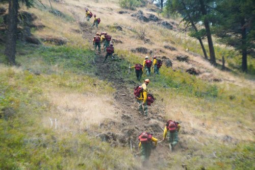
- A crew builds a fire line July 21, 2024, to contain a wildfire near Ukiah.
UKIAH — Firefighters working Sunday, July 21, to contain wildfires near Ukiah focused on protecting structures and scouting ahead of the path of two of the blazes.
The Oregon Department of Forestry Incident Management Team 3 in a press release reported crews on the Monkey Creek and Snake fires looked for potential locations to build direct and contingency lines in difficult terrain and along canyon rims to contain the fires.
The team is managing these fires as the Battle Mountain Complex. The fires started in the late afternoon and evening of July 17.
Firefighters were able to hold and construct line completely around the 3,887-acre North Fork Owens fire, which stands at 10% containment. Crews will continue to establish hose lays for mop up and patrol the perimeter.
Officials plan to shift some resources July 22 to the more active Snake and Monkey Creek fires.
On the 7,499-acre Snake fire, crews held the fire to the west of Highway 395 while focusing on protecting structures and heading off the southeast corner of the fire, toward the town of Dale.
Winds out of the north and northwest are pushing the 18,586-acre Monkey Creek fire south towards Ritter. Firefighters caught a win by keeping the fire north of the John Day Middle Fork River.
Red flag warnings will persist July 22 as firefighters continue to face difficult terrain with limited resources.
According to ODF, difficult terrain is a major factor for where firefighters can place direct line as they attempt to safely maneuver steep, craggy hillsides and loose rocks. Firefighters are especially cautious of rolling debris and loose rocks. Officials have Rapid Extraction Module Support Teams along the fire as an extra precaution for firefighter safety.
Road closures: A closure remains in effect for Highway 395 between mileposts 50 through 90, beginning 35 miles south of Pilot Rock.
Evacuations: For updated evacuation information, visit the Umatilla County Sheriff’s Office Facebook page or sign up for the Umatilla County Emergency Alert System.
Evacuation maps also are available at oregon-oem-geo.hub.arcgis.com.
ODF’s Northeast Oregon District in “extreme” (red) fire danger and there are additional restrictions for industrial forest operations on lands under the department’s protection. Fire restrictions can be found at www.bmidc.org or by calling the Northeast Oregon Fire Prevention line at541-975-3027.
For fire information, go to bluemountainfireinfo.blogspot.com, or visit the Facebook page of the Oregon Department of Forestry’s Northeast Oregon District.
To report a fire, call the Blue Mountain Interagency Dispatch at 541-963-7171 or dial 911.
Total estimated size: 29,972 acres
Monkey Creek: 18,586 acres
North Fork Owens: 3,887 acres
Snake: 7,499 acres
Containment: 2%
Cause: under investigation
Estimated cost: $1,400,000
All resources
Hand crews: 16
Engines: 30
Water Tenders: 5
Dozers: 11
Helicopters: 8
Total Personnel: 586


-
eEdition

-

-