WILDFIRE UPDATE: Community gets update on Battle Mountain Complex
Published 11:55 pm Saturday, July 20, 2024
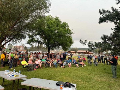
- Ukiah community members July 20, 2024, attend a public meeting on the wildfires near Ukiah.
UKIAH — Crews made good progress against one wildfire burning near Ukiah, but the other fire of the Battle Mountain Complex grew and jumped the North Fork John Day River.
The information came Saturday, July 20, during a community meeting in Ukiah. About 100 people attended the meeting, according to a press release from the Oregon Department of Forestry, and heard updates about fires and evacuation levels.
Tyler McCarty, Incident Management Team 3 incident commander, told the crowd the number of fires stretch from the southwest corner of the state to Northeastern Oregon, leaving the region with little to no firefighting resources.
“Crews and equipment continue to arrive for this complex and that should make a positive impact moving forward,” he said.
The Battle Mountain Complex consists of the 3,642-acre North Fork Owens fire and the 2,766-acre Snake fire.
Firefighters were able to get line around the North Fork Owens fire, ODF reported. But the Snake fire had aggressive growth on the south side where it crossed the North Fork John Day River.
Ground crews, dozers and helicopters worked to stop forward progress and establish line, but winds were pushing the line. During the night of July 21-22, crews will strengthen line where they can and monitor both fires for any spot fires.
Road closures: A closure remains in effect for Highway 395 between mileposts 50 through 90, beginning 35 miles south of Pilot Rock.
Evacuations: Level 1 (be ready), Level 2 (be set) and Level 3 (go now) evacuations are in effect.
Battle Mountain Complex
Level 3
Entire area south of Highway 395 at Copper Creek, between Highway 395 South to the county lines on the west and south side. And then entire area south of Forest Service Road 52, 5 miles east of Highway 395 South down to the county line.
A shelter remains open at the Pendleton Convention Center, 1061 Westgate, Pendleton.
Level 2
The city of Ukiah and Soap Hill south of Ukiah, east side of Highway 395 for 5 miles and down to Forest Service Road 54 and and entire southeast corner of Umatilla County, including the area of Double Snag and Upper Winom areas.
Level 1
• South of Carney Butte, east of Highway 395 South (at milepost 44) to the Umatilla County line, including Albee, Camas Creek, Hideaway Springs, Dixie Ranch and Lehman Springs.
Pilot Rock Fire
Level 2
Area of south of Coombes Canyon Road and north of milepost 32 on Highway 395 South (Gurdane Road) between the county line on the west and just west of East Birch Creek.
Level 1
Area south of milepost 32 on Highway 395 South (Gurdane Road) from east to west county lines and area south of Carney Butte, east of Highway 395 South (at milepost 44) to the Umatilla County line, including Albee, Camas Creek, Hideaway Springs, Dixie Ranch and Lehman Springs.
Between Pilot Rock fire and Battle Mountain Complex
Level 1
Area south of milepost Highway 395 South from east to west county lines, and the area south of Carney Butte, east of Highway 395 South (at mp 44) to the Umatilla County line, including Albee, Camas Creek, Hideaway Springs, Dixie Ranch and Lehman Springs.
Cold Springs Loop area — Weston Mountain
Level 1
South of Highway 204, east of Giger Lane to McDougal Road to include all residences on McDougal, south to Rock Creek including the Pine Creek Road system east of Read and Hawley Mountain.
For updated evacuation information, visit the Umatilla County Sheriff’s Office Facebook page or sign up for the Umatilla County Emergency Alert System.
Evacuation maps also are available at oregon-oem-geo.hub.arcgis.com.
ODF’s Northeast Oregon District in “extreme” (red) fire danger and there are additional restrictions for industrial forest operations on lands under the department’s protection. Fire restrictions can be found at www.bmidc.org or by calling the Northeast Oregon Fire Prevention line at541-975-3027.
For fire information, go to bluemountainfireinfo.blogspot.com, or visit the Facebook page of the Oregon Department of Forestry’s Northeast Oregon District.
To report a fire, call the Blue Mountain Interagency Dispatch at 541-963-7171 or dial 911.
Total estimated size: 6,408 acres
North Fork Owens: 3,642 acres
Snake: 2,766 acres
Containment: 0%
Cause: under investigation
Estimated cost: $250,000
All Resources
Hand Crews: 9
Engines: 15
Water tenders: 5
Dozers: 6
Helicopters: 7

-
eEdition

-

-