Flood concerns emerge in SE Oregon, SW Idaho
Published 3:47 pm Thursday, April 13, 2023
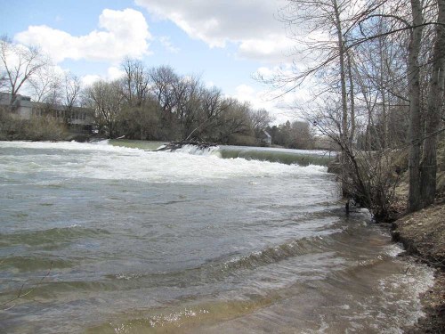
- The diversion dam on the Boise River at Ann Morrison Park in downtown Boise on April 13.
The high snowpack and warm weather are combining to raise the flood risk in parts of southeastern Oregon and southwestern Idaho.
A flood warning for the Malheur River near Vale, Ore., continued April 13.
Trending
Snowmelt and increased reservoir releases will raise river flows, and minor flooding can be expected downstream from the Owyhee Dam, a National Weather Service warning said.
Bully Creek Reservoir was 95% full April 12, according to the U.S. Bureau of Reclamation.
Flooding has already occurred on farm ground in a few spots along the Malheur River, but farmers and ranchers are grateful for the moisture overall, said Kyler Clark, Malheur County Farm Bureau president.
Dan Andersen, a cow-calf and forage producer near Vale, said April 13 that he has a field of 38 acres that is “about 25% underwater.” That will delay planting by a few weeks, “but the overarching benefit of having a full irrigation season will outweigh the delayed planting.”
Erosion may cause some challenges in the area later, depending on the location, he said.
Weiser, Idaho, farmer Dyke Nagasaka, who has experienced flooding in the past, was keeping watch April 13.
Trending
“It’s determined by the weather,” he said. “If warm weather comes and snow melts at a rapid rate, it could cause flooding.”
“The weather pattern we’ve seen so far in April and for the next seven days or so looks pretty ideal as far as melting the snow off in a slower manner where we’re not going to get out of control,” said Troy Lindquist with the National Weather Service in Boise.
Some flooding may occur, such as in flat areas that do not drain well, he said. The Camas Prairie in Idaho’s central mountains is an example.
Higher temperatures on the April 15-16 weekend were expected to increase melt and then give way to cooler conditions in the subsequent couple of days, “allowing rivers and streams to recede as the snowmelt slows down,” Lindquist said. Outlooks for six to 10 and eight to 14 days call for below-normal temperatures and above-normal precipitation.
The worst case is a warm rain adding water at the same time snow is melting, Nagasaka said. The best is a slow melt “so dam operators can manage the runoff better.”
His farm borders the Snake River and the un-dammed Weiser River.
The Snake poses the biggest flood risk to his land because Nagasaka’s land is closest to it in elevation.
“And if it keeps going up, the water table in the area goes up and we can have problems with fields not even bordering the river,” he said.
Flooding can damage equipment as well as fields.
“If I think it (water) is going to get high, I will start pulling irrigation pumps out,” Nagasaka said.
In the Boise area, Boise River managers continue to raise flows to make room for runoff in Lucky Peak, Arrowrock and Anderson Ranch reservoirs.
An increase in the river’s flow past the Glenwood gauge, in the northwest Boise-Garden City area, to 5,000 cubic feet per second is likely early in the week of April 17, said Jon Roberts, water management team lead with the U.S. Army Corps of Engineers Walla Walla District.
“By doing this, we’re slowing down the rate at which the reservoir system is filling so that when snowpack continues into May, we can store that water instead of releasing that through town,” he said.
Having reservoir space available in May, when high-elevation snow starts to melt, ideally means flow does not go to flood stage — 7,000 cfs at Glenwood — or if it does, it stays there only briefly.
“The ultimate goal from our perspective is to never go there if we can,” Roberts said. “We’re lessening that risk by moving water now.”
Marketplace


-
eEdition

-

-
