Precipitation lags in parts of Oregon despite average snowpack
Published 5:30 pm Tuesday, March 7, 2023
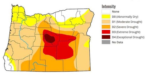
- March 2 Oregon Drought Monitor
PORTLAND — Despite a healthy mountain snowpack, more rainfall is needed at lower elevations to ease drought conditions across much of Oregon.
That’s according to the latest Water Supply Outlook Report issued by the USDA Natural Resources Conservation Service, which tracks streamflows and reservoir storage in 12 water basins statewide.
Trending
As of March 7, snowpack was averaging 112% of normal — ranging from 98% in the Malheur Basin up to 130% in the Harney Basin.
But overall precipitation, which includes rain and snow, continues to lag following a slow start to the water year last fall.
Since Oct. 1, precipitation is averaging just 89% statewide. The Owyhee Basin in far southeast Oregon is faring best at 105%, while the Upper Deschutes Basin in Central Oregon is the driest at 80%.
This area is also experiencing the most severe drought, with all or part of Crook, Deschutes, Jefferson, Harney and Lake counties in “extreme” or “exceptional” drought.
“Water year precipitation deficits loom in a lot of basins,” said Matt Warbritton, a hydrologist for the NRCS in Portland. “It’s really hard to catch up two or three months into the winter when you have that deficit already.”
The stark contrast between snowfall and rain has several explanations, Warbritton said. January was relatively dry, and colder-than-usual weather dating back to November caused precipitation to fall as snow, where it has stayed.
Trending
Once snow begins to melt, it will help to bolster sagging streamflows and reservoir recharge, Warbritton said.
However, he cautioned that dry soils may absorb some of that moisture before it reaches waterways.
Timing of snowmelt is also critical, he added.
“We don’t want to see a rapid melt-off,” Warbritton said. “We want to see an efficient transition of snowmelt into streams as runoff.”
Considering the early season precipitation deficits, Warbritton said forecasters are watching for more snow and rain to catch up. The good news, he said, is there is still more winter left, with peak snow accumulation typically happening from mid-March to early April.
The coming months will be critical to shaping water supplies for the summer, he said.
“Weather patterns can be extremely variable,” he said. “We really just have to wait and see how the season develops as we approach peak snow accumulation.”
Marketplace


-
eEdition

-

-
