New details released on controversial mountain biking project in Ochocos
Published 3:30 pm Friday, November 18, 2022
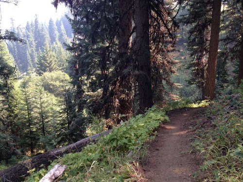
- A pristine singletrack trail climbs up Lookout Mountain, as seen in 2015.
A plan to construct biking trails in a remote area of the Ochoco National Forest east of Prineville has been scaled back by the U.S. Forest Service following a lengthy dialogue with bikers, equestrians and other stakeholders who have been watching the evolution of the project.
Details of the new plans were laid out in a draft environmental assessment for the Lemon Gulch Trails Project, which is now available for public review, according to a news release on Thursday from the Forest Service.
Trending
Plans to develop the new biking trails have ignited spirited debate in Prineville and the mountain biking community of Central Oregon. Some believe the project will help ease tensions on existing trails shared by bikers and equestrians. Others say building the trails will damage sensitive habitat for deer, elk, eagles, cougar and other wildlife.
Still more worry that the project will attract hordes of mountain biking enthusiasts to Prineville, altering the city’s rural character in the same way that outdoor sports transformed Bend’s logging town image. The project is a frequent talking point on the Facebook group “Don’t Bend Prineville.”
The network of bike trails is planned for the west side of the Lookout Mountain Ranger District, about 20 miles northeast of Prineville.
The draft environmental assessment compares five options, including a “no action” alternative.
One alternative has just 19 miles of trail built in the area. Another would see 51.6 miles of new bike trails.
The Forest Service prefers the 27.5-mile alternative, which includes 9.8 miles of beginner trails, 11.2 miles of intermediate trails, and 13.9 miles of advanced trails.
Trending
“It provides a much smaller footprint than the original proposal based on key issues raised in earlier phases of the project, as well as individual and group meetings with permittees, community members, and elected officials,” according to the release.
The Forest Service notes that the 27.5-mile alternative also “reduces trail density in some areas specifically to address wildlife and grazing concerns, while still maintaining a complete mix of trail opportunity.”
Slater Turner, Lookout Mountain district ranger, said the draft environmental assessment was developed over a one-year period and included input from Crook County community leaders, grazing permittees, and tribal members of the Confederated Tribes of the Warm Springs, as well as other stakeholders and interested parties.
“We have taken great care in incorporating a wide variety of comments and look forward to hearing feedback on these alternatives,” said Turner.
A scoping document released in March 2021 laid out original plans for the project, as part of a larger proposal by trail users interested in expanding trail access in the Ochoco National Forest.
The draft environmental assessment is a refined version of the scoping document after widespread public feedback showed cracks in the community over the plan. The criticisms are widespread, ranging from concerns over wildlife habitat to the perceived influx of outside mountain bike groups. Even the name of the project has sparked controversy — critics insist the area be called Lemon Creek, not Lemon Gulch.
In September, opponents organized a protest in front of the Crook County Courthouse in Prineville, urging the Forest Service to rethink the plans and choose another location.
Dave Nielsen, an opponent of the project, said reducing the size of the complex from51.6 miles of trail to 27.5 will not make much difference and the area will still experience negative impacts caused by development.
“Just as many riders and followers will visit the complex to ride, even if the complex is half of that in the original proposal,” said Nielsen, who advocates for the “no action” alternative.
If the plan is adopted, the use of mountain bikes would be banned from Dec. 1 to May 1 for deer and elk winter range protection. The project also includes plans for three parking lots located at different elevations to facilitate shuttling. Kiosks and vault toilets are also planned.
The Forest Service describes the level of development as “low level” to maintain a “rustic character.”
While the single-track trails would be designed for mountain bike use, they would also be available for hikers and trail runners. Some trails would be designed for adaptive mountain biking equipment. Equestrian use would be discouraged and dogs would not be allowed on the trails before July 1.
Kim McCarrel, an avid horseback rider who frequently rides trails in Crook County, said she applauds the Forest Service’s efforts to create purpose-built bike trails that “provide the kinds of experiences many mountain bike riders want.”
McCarrel said equestrians will appreciate the effort to redistribute mountain bike use away from Lookout Mountain and Round Mountain trails, two areas popular with horseback riders. Conflicts between bikes and horseback riders arise frequently on both trails, she said.
“These trails became popular for mountain biking (recently) because they had nowhere else to ride,” said McCarrel. “The steep slopes and short sight lines create ideal conditions for a downhill mountain bike to inadvertently spook a horse and endanger its rider.”
Travis Holman, a mountain biker and vice president of the Central Oregon Trail Alliance, said the 51.6-mile alternative “would do the most to give mountain bikers the best riding experience and therefore presents the best chance to reduce crowding and conflict on other trails.”
But he also acknowledged that the preferred alternative “represents the best compromise of those presented in the EA.”
“We are very heartened to see that impacts to natural and cultural resources can be minimized while still providing a valuable outdoor recreation experience,” Holman said.
“As mountain bikers, we want everyone to have the opportunity to enjoy healthy recreation on our shared public lands while minimizing impacts on natural and cultural resources, and we’re happy to see that this can be accomplished at Lemon Gulch,” Holman adds.
A phased construction is planned if the project moves forward, with an initial set of trails installed followed by one or two years of monitoring before the building of additional trails.
Trail maintenance would be conducted with help from local trail user groups, including Ochoco trails and Central Oregon Trail Alliance.
Public comments will be accepted on the project through Dec. 19. Those wishing to comment may do so electronically on the U.S. Forest Service website (fs.usda.gov/project/?project=58831).
Marketplace


-
eEdition

-

-
