New gates block section of road near Lookout Mountain
Published 1:00 pm Monday, October 3, 2022
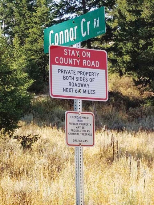
- A sign reminds travelers that a section of the Connor Creek Road, northeast of Lookout Mountain, traverses private property.
The issue of locked gates on previously open roads near Lookout Mountain in eastern Baker County didn’t end when county commissioners earlier this year settled a lawsuit the county filed against a property owner who installed a locked gate in 2017.
That gate prompted the county, in February 2019, to sue the owners of land near the head of Connor Creek, northeast of Lookout Mountain.
Trending
A settlement approved on Jan. 20, 2022, states that the property owner can lock a gate on the road that connects Connor Creek Road to Daly Creek Road only if the fire danger has been extreme for at least 26 straight days.
The county also agreed to pay $125,000 to the landowners who were defendants in the lawsuit — Timber Canyon Ranch LLC, Kennerly Ranches LLC and Forsea River Ranch LLC.
A couple weeks before the settlement was signed, the 3,500-acre property was sold to Allen Potato LLC of North Powder. The settlement terms, including the limitation on when the gate on the Connor Creek Road can be blocked, is binding on the new owner, said Kim Mosier, the county’s attorney.
Although the settlement dealt with the gate on the Connor Creek Road, the document references another road, one cited in a counterclaim the defendants filed in the county’s lawsuit.
This is a section of the Lookout Mountain Road. That road connects to both the Daly Creek and Manning Creek roads, just north of Lookout Mountain itself.
The Daly Creek and Manning Creek roads are public roads that can’t legally be blocked.
Trending
But a section of the Lookout Mountain Road, south of its intersection with the two other roads, crosses private land, some owned by Allen Potato LLC and some by Manning Creek LLC of Durkee, for which there is no public easement, as the county conceded in the lawsuit settlement agreement.
As a result, the county has no legal remedy to prevent locked gates from being installed on that section of the Lookout Mountain Road, County Roadmaster Noodle Perkins said.
He said two locked gates were installed on the road earlier this summer. They are on property owned by Allen Potato LLC.
There is also a sign designating the county and private sections of road, and showing private property boundaries.
The sign states: “Private Road — Not Maintained. Travel At Your Own Risk. This Road May Be Closed at Anytime. No Trespassing Off Of Roadway.”
The lawsuit settlement agreement refers to this as the “upper loop road,” and states that the county concedes the property owner has “exclusive control” over that section of the road. That section of road “is not needed to provide public access to the Connor Creek Road from Daly Creek Road,” according to the settlement. The settlement also states that the county will “execute and record a quitclaim deed releasing any right, title or interest that it might claim in that road,” meaning the upper loop road section of the Lookout Mountain Road.
Perkins said he has had several phone calls from people upset about the new gates.
“There’s nothing we can do about those,” he said, citing the settlement.
County Commissioner Bruce Nichols said the new gates have convinced him that the lawsuit settlement, which he and Commissioner Mark Bennett and Commission Chairman Bill Harvey signed, was not a good deal for the county.
(Harvey had voted against a September 2021 memorandum of understanding to negotiate a settlement in the lawsuit, stating that he disagreed with a sentence, which is part of the settlement agreement, stating that a county official had given landowner Todd Longgood permission to lock the gate on Connor Creek Road.)
“I’m not pleased with our agreement at all,” Nichols said on Tuesday, Sept. 20. “But we’re stuck with it.”
Nichols said he signed the lawsuit settlement because he didn’t want the county to continue to pay attorney fees.
And although Nichols said he was upset that the county paid $125,000 to the previous landowners for a permanent public easement on the Connor Creek Road, he was satisfied that the settlement did address the issue — the gate installed in 2017 — that led to public complaints and ultimately prompted the county to file the lawsuit in 2019.
“I was focused on Connor Creek Road,” Nichols said.
The problem, Nichols said, is that the other road — the upper loop road section of the Lookout Mountain Road — that was previously open is now blocked, in effect trading one section of closed road for another.
He said he didn’t consider the potential for the upper loop road to be gated. That issue wasn’t central to the commissioners’ discussions prior to approving the lawsuit settlement, he said.
Nichols said the county might have been better off pursuing a public easement for the upper loop road than for the Connor Creek Road, thereby maintaining public access to the entire Lookout Mountain Road.
The Lookout Mountain Road is a better maintained and more heavily traveled route than the Connor Creek Road, which becomes very rocky and rough as it descends to the Snake River Road along Brownlee Reservoir.
Harvey said the county accomplished its goal with the lawsuit, gaining a permanent public easement for the Connor Creek Road. He said that road is vital for public and firefighting access.
“That’s the only one we had to deal with,” Harvey said.
He emphasized that the county has no authority over the section of Lookout Mountain Road that has gates.
Harvey said that section of road was built in the 1970s, and has never had a public easement although it has in the past generally been open to the public.
Upper loop road came up in lawsuit
The potential for what amounts to a swap — allowing the landowner to leave the Connor Creek Road gate locked but keeping the entire Lookout Mountain Road open — is part of the lawsuit record.
According to the counterclaim that the defendants’ lawyer, Charles F. Hudson, filed on July 1, 2020, Longgood, “proposed that if the plaintiff agreed with his closure of the (Connor Creek Road), he would agree to keep another private road crossing the property, referred to as the ‘Upper Loop Road,’ open for public use.”
The counterclaim also notes that the upper loop road “ultimately provides a north-south connection between Richland and I-84.”
That connection is severed while the new gates are locked, although it’s still possible to drive between Richland and I-84, the difference being that the route connects to the freeway at Durkee, by way of Manning Creek Road, rather than near Weatherby, by way of Lookout Mountain Road.
Gates prevent loop driving routes
The new gates on the Lookout Mountain Road have a significant effect on public access in the area, Perkins said.
Although, as the lawsuit settlement notes, people still have access to the Connor Creek, Manning Creek and Daly Creek roads, the locked gates do block people from loop routes that also include the Lookout Mountain Road.
Prior to the gates, people could make a loop, either driving the Manning Creek or Daly Creek Road to the Lookout Mountain Road, then continuing south on the Lookout Mountain Road, which runs for more than 10 miles to its end at Interstate 84 near Weatherby.
Conversely, drivers starting at the freeway could head north on the Lookout Mountain Road and connect to either the Manning Creek Road, which runs east to Durkee, the Daly Creek Road, which continues north to Richland, or the Connor Creek Road, which heads east to Brownlee Reservoir.
None of those routes is possible when the gates are locked because the closed section of the Lookout Mountain Road — the upper loop road mentioned in the defendants’ counterclaim and in the lawsuit settlement — is the common link to all the routes.
To access Lookout Mountain itself — a public road leads to the fire lookout on its 7,100-foot summit — and areas to the south, drivers have to come from the south, either on the main road starting from the freeway between Mileposts 337 and 338, or from one of the side roads that branch off from Lookout Mountain Road, including Morgan Creek, Hibbard Creek and Fox Creek roads.
To get to Daly Creek Road and Richland, drivers either have to take Manning Creek Road from Durkee, which is a well-maintained gravel road, or Connor Creek Road from the east, the rough section used primarily by ATVs.
Bennett said he’s had one phone call from someone concerned about the new gates.
Bennett said the gates are an inconvenience since they prevent drivers from making the loops that were possible previously. But he noted that hunters and other visitors still have access to all the public land in the area.
Marketplace

-
eEdition

-

-
