Hurricane-force winds, rain and hail batter Milton-Freewater area
Published 8:53 am Thursday, August 11, 2022
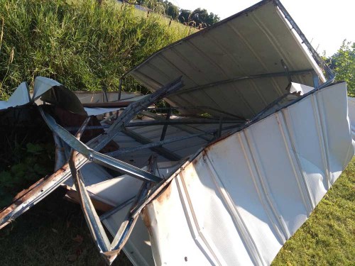
- Milton-Freewater resident Michelle Morgan’s shed rests in a ditch Thursday, Aug. 11, 2022, after a storm hit the town and wind blew the shed over a fence and into the ditch.
MILTON-FREEWATER — The Walla Walla Valley suffered extensive damage from a thunderstorm on Wednesday night, Aug. 10.
“It was a tornado-like storm, with extremely high wind, rain and hail,” Milton-Freewater City Manager Linda Hall said. “Water, street, sewer and electric power crews from the city have been working since last night to restore services and clean things up. It was unusually damaging. Poles were sheared off and trees downed.”
Trending
Much of the city was without power during the night.
“Some customers north of the city but within the utility’s service area are still out,” Hall said. “BPA lost some transmission lines, but their efforts to restore power have borne fruit. The torrential downpour caused flash flood-like conditions in parts of the city.”
Hall reported that downed trees caused property damage outside the city.
“Some did hit structures and roofs and corners were lost,” she said. “A car was smashed.”
The storm launched Michelle Morgan’s 10×10-foot backyard shed over her cyclone fence into an irrigation ditch 40 feet away in her side yard. She lives at 1116 Vining St.
“It escaped the yard,” she said. “Crazy! The wind lifted the old metal shed over the cyclone fence. It landed about half into the ditch. It was a powerful squall.”
Trending
The gust came after the first, heavier hailstorm, Morgan said.
“It was about 8:15,” she said, “post the quarter-inch hail and after the lull before the lighter hail and rain.”
Her family just bought the house, and were planning to redesign the backyard.
“We had just hired a landscaper,” she said. “The shed isn’t needed. We might pull up the pad and plant tomatoes. Next year, the site could be a tomato haven.”
Hall hoped that the forecast for Thursday evening was not a repeat of Wednesday’s weather.
The National Weather Service’s 2:10 p.m. forecast called for a “marginal risk” of severe thunderstorms for the region, according to its Storm Prediction Center. NWS sensors at Pendleton recorded winds no higher than 35 miles per hour Wednesday. Isolated thunderstorms did strike the area, meteorologist Camden Plunkett reported.
However, a team went to the Walla Walla Valley on Thursday afternoon to investigate the reports of storm damage. The investigators did find evidence of high winds in two areas, Senior Meteorologist Larry Nierenberg’s local storm report said.
“What we found out,” he said, “based upon structural damage to an auto shop (owner’s) mobile home near State Line Road around 7:15 p.m., was that wind speeds then reached 60 to 70 miles per hour. Tree limbs were down and corn was blown over.”
However, later in the storm, gusts apparently picked up to hurricane force.
“Around 9 o’clock, they were probably close to 90 mph,” Nierenberg said. “An empty mobile home near the drive-in theater was thrown about 30 feet. We did not find evidence of a tornado. These all appeared to have been straight winds, not twisting.”
Sometimes radar can’t pick up high winds, Nierenberg noted.
“The farther out you go, the higher will the radar beam track,” he said. “And winds can be wrapped in rain, which obscures them.”
Marketplace


-
eEdition

-

-
