La Nina forms and likely to stay through winter; cool, wet winter ahead in NW
Published 7:00 am Monday, October 18, 2021
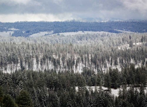
- Snow blankets the forest Oct. 13, 2021, along Interstate 84 in the Blue Mountains outside Pendleton. A timber industry group and coalition of Eastern Oregon counties are attempting to intervene in a lawsuit that would reimpose a total ban on logging certain large trees in six national forests.
SALEM — A La Nina has formed, the National Oceanic and Atmospheric Administration reported Thursday, Oct. 14, portending a wet and cold winter in parts of the Northwest.
NOAA’s Climate Prediction Center forecast the La Nina will peak at moderate strength from November through January. The center hedged a little, estimating a 13% chance the La Nina will diminish before winter.
“We have to have a little humility,” Washington state climatologist Nick Bond said, reacting to the forecast. “But as much as we can, we can count on it.”
La Nina winters generally lead to cool and wet winters in the northern tier of the U.S., including Idaho. Above-average snowpacks in the Cascades, especially in Washington, are the norm. Last winter, a La Nina prevailed. Melting snow helped large Washington irrigation districts withstand this year’s drought.
Farther south, however, La Nina has the opposite effect. A La Nina winter could worsen drought conditions in California and the Southwest.
Oregon roughly south of Roseburg falls in a transition zone where the effects of La Nina are hard to predict, Oregon state climatologist Larry O’Neill said.
During last winter’s La Nina, drought worsened in southern Oregon.
“I tend to temper expectations for that part of the state,” O’Neill said. “The real wildcard is southwest Oregon and most of Eastern Oregon. Washington tends to have a strong La Nina signature. People see that, and they seem to forget Oregon.”
Below-average sea-surface temperatures along the equator in the mid-Pacific start a La Nina. The cool ocean changes wind patterns and storm tracts.
In the past week, the ocean surface in the mid-Pacific has averaged 0.6 degrees Celsius below average, enough to trigger the atmospheric changes. Wind anomalies confirm La Nina conditions are here, according to NOAA.
After peaking in early winter, this La Nina is expected to linger in a weakened state until the early spring, NOAA said.
The second of back-to-back La Nina winters generally start and end sooner than the first, Bond said.
“They do tend to wimp out a little early,” he said. “I think it’s still going to deliver us some good mountain snow.”
In forecasting the strength and staying power of this La Nina, NOAA evaluated 22 climate models. Most predict that sea-surface temperatures will be below average in November, December and January.
While NOAA gave a slight chance for the ocean to return to average temperatures, it ruled out that seas will warm up enough to trigger an El Nino, which foreshadows a warm and dry Northwest winter. Washington’s “snowpack drought” in the winter of 2014-15 occurred during an El Nino.
NOAA will issue a winter forecast Oct. 21. The Climate Prediction Center leans heavily on the sea temperatures in seasonal outlooks. Climatologists are researching how climate change will influence the Pacific’s cool-and-warm cycle.
Bond said some research suggests the cycle will be less pronounced. That could be good news for the drought-stricken Southwest, but leave winter forecasters with less to go on, he said.
“We lose some of that predictability and that’s a little bit of a drag,” Bond said.


-
eEdition

-

-