Prescribed burns to start in Umatilla National Forest
Published 4:34 pm Tuesday, October 12, 2021
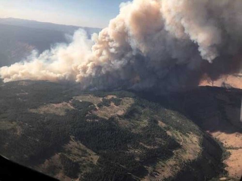
- Taken July 15, 2021 of the Elbow Creek Fire. Courtesy of the Umatilla National Forest.
PENDLETON — Prescribed burns are set to begin soon in the Umatilla National Forest.
The prescribed burns may start this month depending upon weather conditions and could impact camping and hunting opportunities in several portions of the forest, according to a U.S. Forest Service press release.
Trending
All road and trail closures associated with prescribed burns will go into effect prior to their starts. Prescribed burns typically take two to five days to complete. Hunters are advised to plan ahead and avoid camping in the designated prescribed burn areas during this year’s upcoming hunting seasons.
The prescribed burns will be conducted because frequent, low-intensity fire is essential for healthy forests and reducing the risk of uncharacteristic wildfire caused by excessive fuel buildup, according to the press release. Prescribed burning is an effective tool for removing excessive amounts of brush, shrubs, and trees, while also encouraging the growth of native vegetation, according to the press release.
Prescribed burning also is highly dependent on weather conditions. The weather must be within a narrow criteria before prescribed burns can be conducted. Factors such as wind speed and direction, temperatures, relative humidity and fuel moisture are all taken into consideration prior to starting a prescribed burn operation. The current rains and moderate temperatures are creating conditions suitable for prescribed burns.
“From a restoration objective standpoint, late summer and fall provide the best opportunities for the timing of prescribed fires,” said Andrew Stinchfield, deputy fire staff officer. “Fire behavior during fall weather conditions is more likely to align with how the native vegetation has adapted to fire.”
Hunters should be cautious when entering a recently burned area and be aware of increased hazards, particularly snags. Dead or dying trees that remain standing after a fire are unstable, especially in high winds.
The Umatilla National Forest has developed a prescribed fire interactive map displaying planned burning activities. The imap allows the user to zoom in on certain areas and click on a burn unit for more information (such as acreage, status and more). When burning operations begin, the interactive map will be updated to display which burn units are actively burning. Maps of the proposed prescribed burns also are on InciWeb at inciweb.nwcg.gov/incident/5808.
Trending
Additional information on prescribed burning is available on the Umatilla National Forest website at www.fs.usda.gov/umatilla, and on the Forest Facebook page at www.facebook.com/UmatillaNF.


-
eEdition

-

-
