Earlier, hotter, bigger and faster fires are fueling historic fire season
Published 3:30 pm Tuesday, July 20, 2021
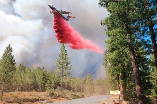
- A tanker drops retardant July 17, 2021, over the Mitchell Monument area at the Bootleg Fire in Southern Oregon.
SALEM — Oregon is experiencing August-like fire danger conditions in mid-July, creating the likelihood of a historic fire season for the second year in a row.
Nearly 500,000 acres have burned from nearly 1,000 fires this year, said Doug Grafe, chief of fire protection for the Oregon Department of Forestry, during a Tuesday, July 20, press call on current fire conditions.
Most fires are caught at under 10 acres, but each has the potential to become a major blaze, fire officials said.
Gov. Kate Brown and state fire response officials warned that conditions were extreme for fire danger that would last for at least three more months. Oregon residents in nearly every point in the state needed to prepare now for how to handle a wildfire emergency, they said.
“Last year’s historic fire season taught us that being prepared can truly be the difference between life and death,” Brown said.
Challenges on all fronts
Brown said the state was facing two big public health challenges this summer, as it had last year: fires with smoke and COVID-19. She said the fires and a recent uptick in COVID-19 infections driven by the new delta variant would not change her plans to have county health officials be the front lines on the pandemic.
A lack of rain and searing summer temperatures have officials scanning the state for new sparks.
Severe drought conditions cover 90% of the state, with 19 counties under drought emergency declarations. The calendar for fire season was accelerated by the record-breaking temperatures at the end of June that hit 117 in Salem and 118 — a state record — in Hermiston.
As of 1 p.m. on July 20, the state reported 22 active fires and a total area burned this season of 405,567 acres.
Oregon is fighting the largest wildfire in the nation, the Bootleg Fire in Fremont-Winema National Forest in Southern Oregon. The fire has burned more than 394,000 acres.
The flames have destroyed 67 residences and 117 other buildings. Only one injury has been reported.
The Bootleg Fire is 32% contained, with protection of towns a top priority. But fire officials said it is possible that up to 100,000 more acres could burn.
“The fire is going to be on the landscape for a long time,” Grafe said.
If it hits the top end of that estimate, the Bootleg Fire would join two other Oregon fires that have burned more than 500,000 acres this century.
The Long Draw Fire in Malheur County in 2012 burned just over 550,000 acres. The Biscuit Fire in the Rogue River–Siskiyou National Forest burned just over 500,000 acres in 2002.
Fire: Getting the upper hand
Other current blazes around the state remain dangerous, but firefighters are getting the upper hand.
State Fire Marshal Mariana Ruiz-Temple pointed to the Grandview Fire north of Sisters in Deschutes County that has burned 6,000 acres as an example of how the state hopes to contain fires early.
An infusion of state funding and updated strategic plans for deploying forces around the state allowed for the pre-positioning of firefighting units and equipment.
The call for a surge of additional resources from local and regional firefighting units kept the blaze away from populated areas.
The fire is now 84% contained.
This is a success story,” Ruiz-Temple said. “The threat to the community was pretty significant.”
Progress has also been made on the Jack Fire in Southern Oregon, though it will likely burn for a long time because of the location and the ability of firefighters to get to the flames.
Commanders on the scene feel “comfortable moving in the right direction,” Grafe said.
A smaller burn causing concern is the 195-acre Bruler Fire, near Santiam Canyon. The terrain is very steep, making access to the flames difficult. One firefighter was hit in the helmet by rolling rocks, but was not significantly injured. The fire is 12% contained.
“I think this one will also be on the landscape for a while,” Grafe said.
He said the fire season had an abnormally early beginning with the Bull Springs Fire near Bend in March.
It was a warning that the state would be in for a protracted battle a year after wildfires burned more than 1 million acres and destroyed thousands of homes during the Labor Day fires of 2020.
“We are facing a long, difficult fire season,” Grafe said.
Virus: Localized, traditional approach
Brown said she wasn’t considering major changes in her June 30 decision to transfer decision-making on COVID-19 policy and abatement to counties.
“We are moving to a more localized, traditional approach,” Brown said.
The Oregon Health Authority reported late Monday that COVID-19 cases statewide were up 30.8% for the period covering July 4 to July 17. The number of cases per 100,000 residents rose to 77.6 from 59.3. The percentage of positive tests rose to 3.8%, up from 3.1%.
Most of Oregon’s 36 counties showed an increase in infections on the state’s risk management website.
Counties reporting a drop in infections included Baker, Curry, Gilliam, Hood River, Jefferson, Polk and Union. Wheeler, Grant and Harney stayed the same.
Some of the highest numbers were in Umatilla County, with the rate of cases per 100,000 rising from 202.5 to 279.8. The positive test rate of 12.4% was more than three times the state average. Only neighboring Morrow County had a higher positive test rate: 14.7%.
Brown said OHA would monitor hospital capacity to ensure no area is strained with COVID-19 patients. State officials are working with local agencies to ensure they have the resources they need.
“The best tool we have for fighting this virus is vaccination,” Brown said.
SALEM — Due to fire danger and limited firefighting resources across the western U.S., effective Thursday, July 22, no campfires will be allowed in state parks and in state-managed forests east of Interstate 5, even in designated campfire areas, according to a press release from the Oregon Department of Forestry.
The ban includes charcoal fires, cooking fires, warming fires, charcoal briquettes, pellet grills, candles, tiki torches and other devices that emit flames or embers. Portable cooking stoves or propane lanterns using liquefied or bottle fuels are allowed, though propane fire pits are not.
The ban covers all state-managed parks and forestlands east of Interstate 5, and includes prohibitions on fires in designated fire rings. The public can also anticipate restrictions in other areas based on fire danger. Restrictions may increase as fire danger rises in other parts of Oregon and will remain in place until conditions moderate.
State agencies strongly encourage checking fire danger levels and associated restrictions in a given area before traveling and daily during a visit.
With hot, dry weather expected to continue and no relief forecasted in the foreseeable future — and several large fires on Oregon’s landscape — the step of banning campfires east of Interstate 5 was deemed a necessary measure to protect life and property in what is already a very challenging and dangerous fire season.
“Every park visitor can do their part to protect the landscapes we all love,”Lisa Sumption, Oregon Parks and Recreation Department director, said. “Help reduce fire risk by bringing meals that don’t require heating or cooking.”
— The Observer
WALLOWA COUNTY — The latest infrared mapping on the Elbow Creek Fire burning in northwestern Wallowa County has its size at 18,599 acres, according to the latest update Wednesday, July 21, from the Type 1 ODF Incident Management Team 3 continuing to fight the blaze. Containment of the fire is estimated at about 20%.
According to a press release, additional resources are being brought in to help with firefighting efforts. The blaze has moved up the priority scale given its growth and complexity as it continues to burn in challenging terrain.
The size of the crew has increased to 469. Link Smith, incident commander for the team, said during a community meeting in Wallowa on July 20 there could be as many as 900 firefighters working to quell the fire in the coming days.
Cooler conditions July 20 and rain overnight is being seen as an opportunity to get an upper hand on the fire. The Elbow Creek area continues to be an area of concern after the fire jumped the waterway July 20 and continues to burn to the northwest.
“Crews are also going direct where they can in the Sickfoot and Deep Creek drainages, while planning for burnout operations where direct fire line construction in steep canyons is not an option,” the update states. “The north and east sides of the fire have not moved within the past few days and firefighters continue to mop up and patrol the area.”
— Ronald Bond, Wallowa County Chieftain