Pendleton shores up levee ahead of high-water season
Published 6:00 am Tuesday, December 29, 2020
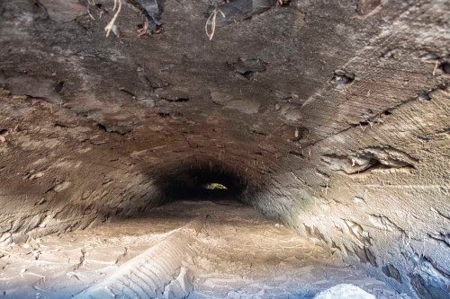
- Light can be seen shining in the far end of an abandoned mill race under the levee near Southeast Third Street in Pendleton on Aug. 10, 2020. The mill race was revealed in February 2020 when floodwaters from the Umatilla rose above the race's opening and began flooding Southeast Third Street.
PENDLETON — Ten months after floods inundated Pendleton, the city is patching over one of the last areas where the Umatilla River unexpectedly penetrated the city’s flood defense system.
Contractors started repair work on Monday, Dec. 28, on the Pendleton levee near Southeast Third Street. Pendleton Public Works Director Bob Patterson said crews will extract an old arch contained within the levee before installing a new wall and applying grout to completely seal off that area of the levee from future high-water events. The contractor expects to complete the project on Wednesday, Dec. 30.
Trending
In Pendleton, the February floods destroyed homes and damaged businesses, battering a community that was trying to withstand its second major flood in as many years.
The flood tested Pendleton’s infrastructure, and water got through Pendleton’s levee system at two different points. On the west end of town, flood waters breached a levee near some industrial land, flooding Keystone RV Co. and Cor-Tek, forcing the large-scale employers to either curtail or suspend operations while they made repairs. The state eventually granted Pendleton $1.8 million to repair that section of the levee.
But water bypassed the levee section near Southeast Third Street for a much different reason.
Instead of breaching the levee section, the water seeped through it, the result of an artifact from Pendleton’s early days. Flood waters threatened the East Oregonian offices and some nearby homes and businesses, but city staff were able to drain the water before it did significant damage.
Before the city built the levee, a resident had built a mill race, a channel that carries water to a mill wheel. Instead of demolishing it, the city built the levee over the mill race and listed it in internal documents as “abandoned.” Patterson said modern-day city staff interpreted abandoned to mean in-filled, only to learn they were mistaken during the flood.
“We didn’t know it was there,” he said.
Trending
The levee was eligible for repairs through a U.S. Army Corps of Engineers program. The corps hired Vancouver, Washington, contractor KEU to conduct the repairs and is covering the costs.
The February flood shattered expectations for how high the Umatilla River could rise, flooding areas thought to be beyond the floodplain and causing communities around the Northwest to fortify their flood protection infrastructure.
In an email, Patterson explained how the flood surpassed authorities’ previous estimates.
“We were also just provided the flow estimate this week for the February event — 28,900 cubic feet per second (CFS) at the Pendleton gaging station location,” he wrote. “The 100-year, or base flood event, was calculated in the late 1990s to be about 22,500 CFS for this location, with the prior highest measured flow of record at about 15,500 CFS in 1965.”
Patterson said the city’s bridges and levees held strong during the flood for the most part, but city staff will still look at the Umatilla River and McKay Creek with concern during the late winter and early spring now that they know what they’re capable of.
“It doesn’t mean we’ll sleep any easier,” he said. “Probably not.”
Patterson said Pendleton’s flooding events were caused by a combination of melting snow runoff and heavy rain in the Blue Mountains. In upcoming years, Patterson said he’s worried about the possibility of snowmelt combined with heavy rain directly over Pendleton, which would put more pressure on the city’s flood protection system.
Marketplace


-
eEdition

-

-
