National Weather Service expects mild snowfall over the next month
Published 8:00 am Tuesday, December 15, 2020
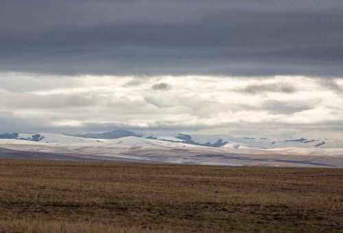
- Snow blankets the Blue Mountains on Monday, Dec. 14, 2020.
PENDLETON — With less than a week until the official start to winter, the weather is just starting to indicate a change in seasons.
Light snowfall fell in the region Sunday, Dec. 13. According to National Weather Service meteorologist Matt Callihan, Pendleton saw 0.4 inches, while further east in Meacham 0.21 inches of snow was recorded. Most other areas in the region saw trace amounts of snow, if they saw any at all.
Callihan said the recent weather system continues the recent trend of higher than normal precipitation paired with higher than normal temperatures. For Eastern Oregon, that’s meant more rain and less snow at lower elevations.
Callihan said forecasters were initially anticipating freezing rain rather than snow on Dec. 13.
More storms are projected for later in the week going into the weekend, but Callihan said snow is more likely in the region’s higher elevations rather than lower lying areas like Pendleton and Hermiston.
Callihan said this trend of higher precipitation and higher temperatures is expected to continue for the next month, but that doesn’t mean it can’t change. He added that most of the storms that have swept across Eastern Oregon have originated from the Pacific Ocean, which leads to the milder temperatures.
But should a storm come from Canada, bringing arctic air with it, Callihan said the region could see more snowstorms.
“It’s bound to happen at some point,” he said, adding that it will also depend on whether an arctic system would be able to penetrate the Oregon-Washington border.
The other factor in snowfall counts is what it will look like once temperatures rise in the spring.
The Pendleton area has been battered for two consecutive years with consistent flooding.
In 2019, the McKay Dam was overwhelmed with rain and snowmelt to the point that runoff flooded McKay Creek and some of the neighborhoods around it. Flooding was even worse in February when the Umatilla River was inundated with water, causing residential displacement and significant property damage in Pendleton, the Umatilla Indian Reservation and the Echo and Milton-Freewater areas.
Callihan said it’s difficult to project potential flooding conditions this far in advance, but one thing that portends well for the region has been the relative stability of weather conditions so far this season.
Callihan said it’s a good sign the region has eased into winter conditions rather than a sudden plummet. If the area gradually transitions to spring the same way it is transitioning into winter, Callihan said it could make the cycles of snow and rain that led to the flooding less likely.
The area has a ways to go before it exceeds historical norms.
According to the U.S. Department of Agriculture’s Natural Resources Conservation Service, the Umatilla, Walla Walla and Willow basins’ snow water equivalent levels are 87% of their normal levels.


-
eEdition

-

-