New groundwater study takes hold in the Walla Walla River Basin
Published 11:30 am Friday, September 11, 2020
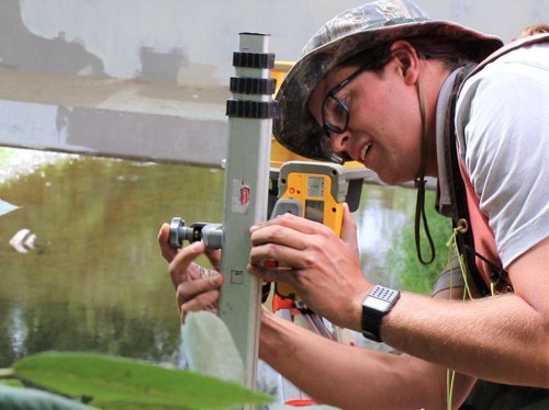
- Walla Walla Watershed Basin Council Watershed technician Luke Adams takes measurements near the Walla Walla River.
WALLA WALLA, Wash. — A new bi-state groundwater study will collect data to help future water management decisions in the Walla Walla River Basin.
Water levels in the basin continue to decline in both Washington and Oregon, especially during peak summertime demand and in regional aquifers. Poor instream flows threaten culturally essential fish populations in the basin, according to an announcement.
Most groundwater is used for irrigated agriculture, but also industrial, domestic and livestock needs.
Both states have taken steps to solve the issue over the past several years, but water levels continue to drop, according to a blog post from the Department of Ecology.
“In this first year of study, the (United States Geological Survey) will compile existing information, identify and fill gaps in water-level monitoring and collect reconnaissance level geochemical information,” according to an overview.
The data will guide the development of a work plan for investigation of the basin’s movement, distribution and management of groundwater.
Jeff Wiles, supervisory hydrologic technician for United States Geological Survey, said in a video from the state Department of Ecology, a seepage run measures the gains and losses of the streams in the basin.
“In some reaches (lengths of the stream), the groundwater is influencing the stream. In other reaches, we’ll have the stream actually recharging the aquifer,” he said in the video.
Surface water, groundwater interaction tells officials how agriculture and municipal uses of water are impacting the groundwater levels overtime, Chris Kowitz, north central regional manager for the Oregon Water Resources Department said in the video.
He said a report on the findings will be assembled.
The groundwater study data will help stakeholders in the basin better understand the extent and connectivity of groundwater, the impacts of pumping on groundwater levels, and the locations of gaining and losing stream lengths and the volume of water being exchanged in those, according to United States Geological Survey.
Ecology, Oregon Water Resources Department, Confederated Tribes of the Umatilla Indian Reservation and USGS Oregon and Washington Water Science Centers are working together.
According to the blog post, they are conducting the first comprehensive study of its kind in the basin.