Oregon forecast predicts near-average weather through July
Published 2:30 pm Thursday, April 23, 2020
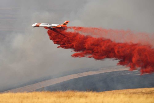
- A firefighting air tanker drops a load of fire retardant into a draw in Harrington Canyon as a large wildfire burned out of control on Aug. 17, 2018, southwest of Pilot Rock.
SALEM — May could be cooler and wetter in Oregon than might be expected based on past years with similar ocean conditions, according to a seasonal forecast issued by the state Department of Forestry and Department of Agriculture.
Officials, however, are still bracing for an intense wildfire season amid severe drought conditions, especially in Southern Oregon.
Trending
Pete Parsons, meteorologist for ODF, said a weak El Niño — characterized by warmer ocean temperatures in the equatorial Pacific Ocean — resulted in a predictably dry winter statewide. Agricultural basins are averaging just 80% of total average precipitation for the water year dating back to Oct. 1, 2019.
The National Oceanic and Atmospheric Administration’s Climate Prediction Center is calling for more of the same over the next three months, with a greater chance for continued hot and dry summer weather.
But Parsons said he believes the averages could be much closer to normal, using 1959, 1970 and 2005 as years with similar climatic conditions for comparison. Those years suggest above-average rainfall during May and slightly below-average temperatures, which helped to even out the thirstier months of June and July.
“This is a local effect that happens here with El Niño,” Parsons said in a video posted to YouTube. “You get that brief cool down, and then it will dry out as we go back into the summer. Let’s look out for May not being as warm as you might think, a little on the cool side or at least moderate, and possibly a little more precipitation than normal.”
Parsons said the Pacific may transition from El Niño to neutral or possibly to a weak La Niña heading into fall, as happened before during the similar years. La Niña typically means a cooler, wetter winter ahead for the Northwest.
“It’s not a perfect match. But it’s a really good match,” Parsons said. “These years have been doing an excellent job giving us some idea what the jet stream patterns are going to look like, and ultimately what the weather is going to look like.”
Trending
Nick Yonker, meteorology and smoke management program manager at ODF, said he recently briefed State Forester Peter Daugherty about the forecast and potential implications for the wildfire season.
As of April 14, nearly 90% of Oregon is in some stage of drought, from “abnormally dry” to severe drought in southwest Oregon that is now creeping into the southern end of the Willamette Valley. Portions of northeast Oregon remain drought-free, thanks to ample snowpack in the Blue Mountains.
“I think the likelihood for an above-normal fire season is reasonable at this point,” Yonker said. “I’d be somewhat surprised if it would be less.”
Gov. Kate Brown already declared a drought emergency in Klamath County on Feb. 25. Jackson and Curry counties have also requested declarations.
“If we stay dry as we go into the summer, I think we will probably have a higher likelihood of above-normal fires and increasing drought concern for agricultural interests,” Yonker said.
Last year was a relatively mild summer for wildfires on state-protected land. The largest blaze, the Milepost 97 fire near Canyonville, burned 13,119 acres in July 2019. All together, ODF reported 738 fires that burned 16,479 acres — far less than the 10-year average of 39,000 acres.
Part of the reason, Yonker said, was less dry lightning sparking blazes in difficult, remote terrain. While month-to-month temperature variations in Parsons’ forecast do balance out in terms of extreme heat, the similar years do indicate an elevated chance of lightning.
“The ability to make good long-range forecasts is really in its infancy,” Yonker cautioned. “We try, but there are too many factors.”
Marketplace


-
eEdition

-

-
