Early season snowfall, precipitation lagging across Oregon
Published 11:00 am Thursday, November 21, 2019
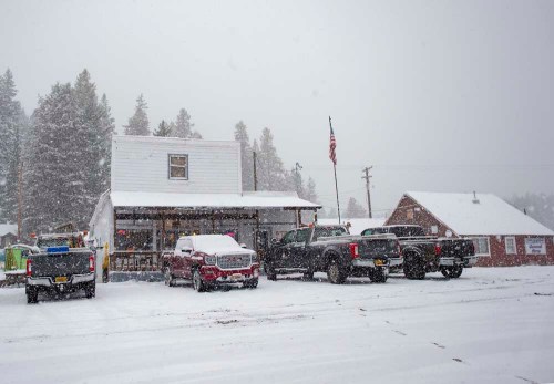
- Trucks sit gathering snow outside of the Oregon Trail Store and Deli in Meacham on Wednesday, Oct. 9, 2019. Foliage bows under the weight of snow from an October storm in the Blue Mountains. Overall precipitation in Oregon is measuring well below normal for the water year that began Sept. 30, 2019.
SALEM — A dry start to the fall season is raising some concerns among state water managers about the possibility of drought returning to Oregon, especially in the Rogue and Umpqua river basins.
Overall precipitation is measuring well below normal for the water year that began Sept. 30, according to the latest water conditions report from the Oregon Water Resources Department. The deficit ranges from nearly an inch below normal east of the Cascades, to more than 5 inches below normal in parts of Southwest Oregon.
While no part of the state is currently in drought, the agency’s report states that could change in the coming weeks unless there is a marked change in weather patterns.
Statewide, average precipitation at sites measured by the USDA Natural Resources Conservation Service is just 45% of normal across the state.
The highest totals as of Nov. 18 were in Northeast Oregon, including 71% in the Umatilla, Walla Walla and Willow basins and 67% in the Grande Ronde, Powder, Burnt and Imnaha basins.
The lowest totals are in southwest and south-central Oregon, at 26% of normal in the Rogue and Umpqua basins; 24% in the Klamath Basin; and 21% in the Goose Lake and Lake County area.
The Willamette Basin — home of the state’s leading agricultural counties by value of products — is trending right in the middle at 45% of normal.
Stream flows are still averaging slightly above normal across Oregon, thanks to drought-busting record snowfall in February and heavy rains in April that bolstered supplies over the summer. However, the report cautions more is needed to maintain that positive momentum.
“In response to recent dry weather, flows in many streams in Western Oregon have declined significantly over the past two weeks,” the report states. “In some areas of Southwestern Oregon, stream flows are less than 10% of normal.”
The highest stream flows were in the Sandy, North Coast, Mid Coast and Umatilla basins at more than 130% of normal for the month of October, dropping down to about 53% of normal on the South Coast.
As irrigators start eyeing relief, short- and long-term weather forecasts offer a mixed bag.
The National Oceanic and Atmospheric Administration’s Climate Prediction Center predicts below-average precipitation over the next two weeks, and an equal chance for above- or below-normal precipitation across most of the state over the next three months.
The lone exception, once again, is Southwest Oregon, which is looking at a greater chance of continued dry conditions.
At this time last year, the entire state of Oregon was listed in some stage of drought, including extreme drought across portions of Southern Oregon and Central Oregon. Then came the February snow and April rain, proving just how quickly conditions can change.
“We always prefer to see a good start to the water year,” said Racquel Rancier, spokeswoman for the OWRD. “This year has been a slow start with below-normal precipitation, but it really is too early to be able to determine how water conditions will look in a few months and whether drought conditions will occur.”


-
eEdition

-

-